Cyclone Phailin
| Extremely severe cyclonic storm (IMD scale) | |
|---|---|
| Category 5 (Saffir–Simpson scale) | |

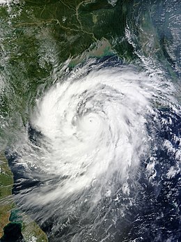
Phailin at peak intensity on October 11
|
|
| Formed | October 5, 2013 |
| Dissipated | October 14, 2013 |
| Highest winds |
3-minute sustained: 215 km/h (130 mph) 1-minute sustained: 260 km/h (160 mph) |
| Lowest pressure | 940 hPa (mbar); 27.76 inHg |
| Fatalities | 45 total |
| Damage | $696 million (2013 USD) |
| Areas affected | Thailand, Myanmar, India |
| Part of the 2013 Pacific typhoon season and the North Indian Ocean cyclone season |
|
Extremely Severe Cyclonic Storm Phailin (Thai: ไพลิน meaning "sapphire") was the most intense tropical cyclone to make landfall in India since the 1999 Odisha cyclone. The system was first noted as a tropical depression on October 4, 2013 within the Gulf of Thailand, to the west of Phnom Penh in Cambodia. Over the next few days, it moved westwards within an area of low to moderate vertical wind shear, before as it passed over the Malay Peninsula, it moved out of the Western Pacific Basin on October 6. It emerged into the Andaman Sea during the next day and moved west-northwest into an improving environment for further development before the system was named Phailin on October 9, after it had developed into a cyclonic storm and passed over the Andaman and Nicobar Islands into the Bay of Bengal.
During the next day Phailin intensified rapidly and became a very severe cyclonic storm on October 10, equivalent to a category 1 hurricane on the Saffir-Simpson hurricane wind scale (SSHWS). On October 11, the system became equivalent to a category 5 hurricane on the SSHWS before it started to weaken during the next day as it approached the Indian state of Odisha. It made landfall later that day, near Gopalpur in Odisha coast at around 2130 IST (1600 UTC). It subsequently weakened over land as a result of frictional forces, before it was last noted on October 14, as it degenerated into a well marked area of low pressure.
Officials from Odisha's state government said that around 12 million people may be affected. The cyclone prompted India's biggest evacuation in 23 years with more than 550,000 people moved up from the coastline in Odisha and Andhra Pradesh to safer places. Most of the evacuated people had been sheltered in 500 specially-built cyclone camps in the two states. Each cyclone shelter could accommodate up to 1,500 people while their ground floors might be used as cattle shelters.
On October 4, the Japan Meteorological Agency started to monitor a tropical depression that had developed in the Gulf of Thailand, about 400 km (250 mi) west of Ho Chi Minh City in Vietnam. Over the next couple of days the system moved westward within an area of low to moderate vertical wind shear before it passed over the Malay Peninsula and moved out of the Western Pacific Basin on October 6. The system then subsequently emerged into the Andaman Sea during the next day, before the India Meteorological Department (IMD) started to monitor the system as Depression BOB 04 early on October 8. During that day the system moved towards the west-northwest into an environment for more development before the IMD reported that the system had become a deep depression early on October 9 as it intensified and consolidated further. The United States Joint Typhoon Warning Center (JTWC) subsequently initiated advisories on the depression and designated it as Tropical Cyclone 02B, before the system slightly weakened, as it passed near to Mayabunder in the Andaman Islands and moved into the Bay of Bengal. After moving into the Bay of Bengal, the system quickly reorganized as it moved along the southern edge of a subtropical ridge of high pressure. The IMD reported that the system had intensified into a cyclonic storm and named it Phailin.
...
Wikipedia
