2002 Pacific hurricane season
| 2002 Pacific hurricane season | |
|---|---|

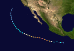
Season summary map
|
|
| Seasonal boundaries | |
| First system formed | May 24, 2002 |
| Last system dissipated | November 16, 2002 |
| Strongest storm | |
| Name | Kenna |
| • Maximum winds | 165 mph (270 km/h) (1-minute sustained) |
| • Lowest pressure | 913 mbar (hPa; 26.96 inHg) |
| Seasonal statistics | |
| Total depressions | 19 official, 2 unofficial |
| Total storms | 15 official, 1 unofficial |
| Hurricanes | 8 |
| Major hurricanes (Cat. 3+) |
6 |
| Total fatalities | 4 direct, 3 indirect |
| Total damage | $101 million (2002 USD) |
| Related articles | |
| Category 3 hurricane (SSHWS) | |
| Duration | May 24 – June 1 |
|---|---|
| Peak intensity | 115 mph (185 km/h) (1-min) 960 mbar (hPa) |
| Tropical storm (SSHWS) | |
| Duration | June 8 – June 11 |
|---|---|
| Peak intensity | 60 mph (95 km/h) (1-min) 997 mbar (hPa) |
| Tropical depression (SSHWS) | |
| Duration | June 27 – June 29 |
|---|---|
| Peak intensity | 35 mph (55 km/h) (1-min) 1006 mbar (hPa) |
| Tropical storm (SSHWS) | |
| Duration | July 9 – July 16 |
|---|---|
| Peak intensity | 65 mph (100 km/h) (1-min) 994 mbar (hPa) |
| Category 2 hurricane (SSHWS) | |
| Duration | July 20 – July 26 |
|---|---|
| Peak intensity | 105 mph (165 km/h) (1-min) 970 mbar (hPa) |
| Category 5 hurricane (SSHWS) | |
| Duration | July 23 – July 30 |
|---|---|
| Peak intensity | 160 mph (260 km/h) (1-min) 921 mbar (hPa) |
| Tropical depression (SSHWS) | |
| Duration | August 6 – August 8 |
|---|---|
| Peak intensity | 35 mph (55 km/h) (1-min) 1008 mbar (hPa) |
| Category 4 hurricane (SSHWS) | |
| Duration | August 21 – September 3 |
|---|---|
| Peak intensity | 145 mph (230 km/h) (1-min) 936 mbar (hPa) |
| Tropical storm (SSHWS) | |
| Duration | August 22 – August 28 |
|---|---|
| Peak intensity | 65 mph (100 km/h) (1-min) 995 mbar (hPa) |
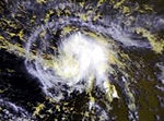
The 2002 Pacific hurricane season was a slightly above average Pacific hurricane season that saw three tropical cyclones reach Category 5 intensity on the Saffir-Simpson Hurricane Wind Scale. The strongest storm this year was Hurricane Kenna, which reached Category 5 on the Saffir-Simpson Hurricane Scale. It made landfall near Puerto Vallarta, located in the Mexican state of Jalisco, on October 25. The hurricane killed four people and was the third most powerful hurricanes to ever strike the western coast of Mexico, hitting with winds of 140 mph (as well as the strongest landfall in terms of windspeed since Hurricane Madeline in 1976). Elsewhere, Tropical Storm Julio made landfall in Mexico, and Tropical Storm Boris dumped torrential rain along the Mexican coast, despite remaining offshore.
The season officially began on May 15, 2002 for the Eastern Pacific, and June 1, 2002 for the Central Pacific. It ended on November 30 for both regions. These dates delimit the time when most tropical cyclones form in this part of the Pacific Ocean. The first system formed on May 24 and the final depression dissipated on November 16.
Other storms were individually unusual. Hurricanes Elida and Hernan also reached Category 5 intensity, but neither caused any damage. Hurricane Fausto had no effect on land, but it regenerated into a weak tropical storm at an abnormally high latitude.
There were 15 tropical storms in the eastern Pacific Ocean in the 2002 season. Of those, eight became hurricanes, of which six became major hurricanes by reaching Category 3 or higher on the Saffir Simpson Scale. Three reached Category 5 intensity, a record shared with the 1994 season. Four tropical depressions formed and dissipated before reaching the intensity of a tropical storm. In the Central Pacific Hurricane Center's area of responsibility, one tropical storm and two hurricanes formed, with one of the hurricanes intensifying into a major hurricane. In the eastern Pacific proper, the season saw below average activity in terms of the number of total storms and hurricanes, but about average activity in terms of major hurricanes. A moderately strong El Niño, ongoing during the season, may have contributed to the disproportionate number of major hurricanes, as well as reduced activity in the Atlantic. Also of note was an unusual gap in storm formation during the first three weeks of August in this season, histrocally a prime period for tropical cyclone formation.
...
Wikipedia


