Čurug
|
Čurug Чуруг |
|
|---|---|
| Village | |

Čurug, center
|
|
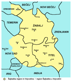
 Map of the Žabalj municipality and Šajkaška region (yellow), showing the location of Čurug |
|
| Map of the Žabalj municipality and Šajkaška region (yellow), showing the location of Čurug | |
| Coordinates: 45°28′N 20°4′E / 45.467°N 20.067°E | |
| Country |
|
| Province |
|
| Population (2002) | |
| • Total | 8,882 |
| Time zone | CET (UTC+1) |
| • Summer (DST) | CEST (UTC+2) |
Čurug (Serbian Cyrillic: Чуруг) is a village in the municipality of Žabalj, in the South Bačka District of Serbia. It is situated in the Autonomous Province of Vojvodina. The village has a Serb ethnic majority and its population numbering 8,882 people (2002 census).
In Serbian, the village is known as Чуруг or Čurug, in Croatian as Čurug, and in Hungarian as Csúrog.
The village of Čurug is situated in the wide lowlands of the south-eastern part of the Bačka region, in the place where the river Tisa creates its greatest meander down its flow.
It is bordered by the settlements of Bačko Gradište (to the north), Kumane and Novi Bečej (northeast), Taraš (east), Gospođinci (south), Temerin (southwest), Nadalj (northwest), and Žabalj (south-southeast).
The fact of it being settled in one of the highest parts of planes (82 m sea-level) is one of the main reasons the village always managed to avoid floods, and for being constantly populated during its long history.
Several archaeological sites are located around the village (Archeological Site of Stari Vinogradi), mainly from time of Roman Empire and early Middle Ages. Traces of ancient Indo-European peoples, notably of Iazyges and Celts, are also discovered at this location. The archaeologists have found traces of Slavic settlement from the 9th-10th century, as well as the more distinctive ethnic traces of Serb settlement from the 15th century.
...
Wikipedia

