Temerin
|
Temerin Темерин |
||
|---|---|---|
| Town and municipality | ||

Town center of Temerin
|
||
|
||
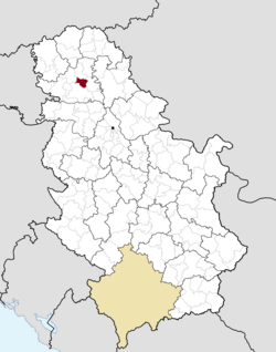
 Location of the municipality of Temerin within Serbia |
||
| Coordinates: 45°25′N 19°53′E / 45.417°N 19.883°ECoordinates: 45°25′N 19°53′E / 45.417°N 19.883°E | ||
| Country |
|
|
| Province | Vojvodina | |
| District | South Bačka | |
| Settlements | 3 | |
| Government | ||
| • Mayor | Đuro Žiga | |
| Area | ||
| • Municipality | 170 km2 (70 sq mi) | |
| Population (2011 census) | ||
| • Town | 19,661 | |
| • Municipality | 28,287 | |
| Time zone | CET (UTC+1) | |
| • Summer (DST) | CEST (UTC+2) | |
| Postal code | 21235 | |
| Area code | +381 21 | |
| Car plates | NS | |
| Website | www |
|
Temerin (Serbian Cyrillic: Темерин; Hungarian: Temerin, pronounced [ˈtɛmɛrin]) is a town and municipality located in the South Bačka District of the autonomous province of Vojvodina, Serbia. Temerin town has a population of 19,613, and Temerin municipality 28,287.
In Serbian, the town is known as Temerin (Темерин), in Hungarian as Temerin, in German as Temeri, and in Croatian as Temerin.
Territory of Municipality of Temerin is in the southeast part of Bačka plain. On its east side it borders on Municipality of Žabalj, on the north side on Municipality of Srbobran, Municipality of Vrbas is on the west and Novi Sad borders on its south side.
The most influential factor in the development of Temerin is the vicinity of the most developed business center in Vojvodina – Novi Sad. The territory of the Municipality of Temerin covers the area of around 170 km² (66 mi²), and has a shape of irregular trapezoid, spreading in the northwest – southeast direction. The longer axis, covering the direction Sirig–Temerin, is 14 km long and the shorter axis in Bački Jarak–Temerin direction is 11 km long.
The boundaries of municipality are artificial lines, mostly in rectilinear directions. The only natural boundary of the municipality is on its northeast side where it follows the water current of river Jegrička. On the southeast side the boundary is made with the embankment called Rimski Šanac II.
...
Wikipedia

