Zams
| Zams | ||
|---|---|---|
 |
||
|
||
| Location within Austria | ||
| Coordinates: 47°09′28″N 10°35′22″E / 47.15778°N 10.58944°ECoordinates: 47°09′28″N 10°35′22″E / 47.15778°N 10.58944°E | ||
| Country | Austria | |
| State | Tyrol | |
| District | Landeck | |
| Government | ||
| • Mayor | Siegmund Geiger (ŐVP) | |
| Area | ||
| • Total | 124.97 km2 (48.25 sq mi) | |
| Elevation | 767 m (2,516 ft) | |
| Population (1 January 2016) | ||
| • Total | 3,414 | |
| • Density | 27/km2 (71/sq mi) | |
| Time zone | CET (UTC+1) | |
| • Summer (DST) | CEST (UTC+2) | |
| Postal code | 6511 | |
| Area code | 05442 | |
| Vehicle registration | LA | |
| Website | www.zams.at | |
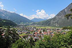
Zams is a municipality in the district of Landeck in the Austrian state of Tyrol.
It is situated in a river basin together with its neighbour town Landeck near the rivers Inn and Sanna. The geographical location is 47°28′N 10°22′E / 47.467°N 10.367°E. Here, the old roads coming from Vinschgau, Engadin, Bavaria and Lake Constance cross.
The free-standing church tower is a notable feature of the town. In 1911, a fire burned half the village to ash and destroyed much of the old man-made structures. The tower remained, and the church was established about fifty meters away.
Zams: Lötz, Rease, Oberdorf, Engere, Oberreit, Unterreit, Siedlung, Riefe
Zammerberg: Falterschein, Grist, Kronburg, Lahnbach, Rifenal, Schwaighof, Tatschhof, Anreit
Ausserfern: Madau
Bach, Austria, Fließ, Flirsch, Gramais, Grins, Imst, Kaisers, Landeck, Schönwies, Stanz bei Landeck, Strengen, Wenns
...
Wikipedia


