Inn River
| Inn | |
|---|---|

Map highlighting the Inn
|
|
| Other name(s) | Romansh: En |
| Countries | Switzerland, Austria, Germany |
| Cities | St. Moritz, Scuol, Landeck, Innsbruck, Wörgl, Kufstein, Rosenheim, Wasserburg am Inn, Mühldorf am Inn, Braunau am Inn, Schärding, Passau |
| Basin features | |
| Main source |
Swiss Alps (Lägh dal Lunghin) 2,484 m (8,150 ft) 46°25′00″N 9°40′35″E / 46.41673°N 9.67645°E |
| River mouth |
Danube (Passau) 291 m (955 ft) 48°34′25″N 13°28′38″E / 48.57353°N 13.47713°ECoordinates: 48°34′25″N 13°28′38″E / 48.57353°N 13.47713°E |
| Basin size | 26,130 km2 (10,090 sq mi) |
| Physical characteristics | |
| Length | 517 km (321 mi) |
| Discharge |
|
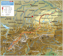
The Inn (Latin: Aenus;Romansh: En) is a river in Switzerland, Austria and Germany. It is a right tributary of the Danube and is 517 kilometres (321 mi) long. The highest point of its drainage basin is the summit of Piz Bernina, at 4,049 metres (13,284 ft). The Engadine, the valley of the En, is the only Swiss valley from which its waters ends in the Black Sea (via the Danube).
The source is located in the Swiss Alps, west of St. Moritz in the Engadine region, which is named after the river (Romansh Engiadina; Latin vallis Eniatina). Shortly after it leaves its source, the Inn flows through the largest lakes on its course, Lake Sils and Lake Silvaplana. It runs north-eastwards, entering Austria, and from Landeck eastwards through the Austrian state of Tyrol and its capital, Innsbruck (bridge over the Inn), and crosses the border into Bavaria near Kufstein.
On Bavarian territory the river runs northwards and passes Rosenheim, Wasserburg am Inn, and Waldkraiburg; then it turns east, runs through Mühldorf and Neuötting and is enlarged by two major tributaries, the Alz and the Salzach.
...
Wikipedia
