Wrangel island
| Native name: о́стров Вра́нгеля | |
|---|---|

Coastal landscape of Wrangel Island
|
|

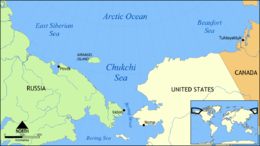
Location of Wrangel Island
|
|
| Geography | |
| Location | Arctic Ocean |
| Coordinates | 71°14′N 179°25′W / 71.233°N 179.417°WCoordinates: 71°14′N 179°25′W / 71.233°N 179.417°W |
| Area | 7,600 km2 (2,900 sq mi) |
| Highest elevation | 1,096 m (3,596 ft) |
| Highest point | Sovetskaya Mountain |
| Administration | |
| Federal District | Far Eastern |
| Autonomous Okrug | Chukotka |
| Additional information | |
| Official name | Natural System of Wrangel Island Reserve |
| Type | Natural |
| Criteria | ix, x |
| Designated | 2004 (28th session) |
| Reference no. | 1023 |
| State Party | Russian Federation |
| Region | Asia |
Wrangel Island (Russian: о́стров Вра́нгеля, tr. ostrov Vrangelya; IPA: [ˈostrəf ˈvrangʲɪlʲə]) is an island in the Arctic Ocean, between the Chukchi Sea and East Siberian Sea. Wrangel Island lies astride the 180° meridian. The International Date Line is displaced eastwards at this latitude to avoid the island as well as the Chukchi Peninsula on the Russian mainland. The closest land to Wrangel Island is tiny and rocky Herald Island located 60 km (37 mi) to the east. The distance to the closest point on the mainland is 140 km (87 mi). Wrangel Island may have been the last place on earth where mammoths survived.
Nearly all of Wrangel Island, and Herald Island, are a federally protected nature sanctuary administered by Russia's Ministry of Natural Resources and Environment. The island, and its surrounding waters, were classified as a "Zapovednik" (a "strict nature reserve") in 1976 and, as such, receive the highest level of protection and exclude practically all human activity other than for scientific purposes. The Chukotka Regional government extended the marine protected area out to 24 nautical miles in 1999. As of 2003, there were four rangers who reside on the island year-round. In addition a core group of about 12 scientists conduct research during the summer months.
Wrangel Island is about 125 km (78 mi) wide and 7,600 km2 (2,900 sq mi) in area. It consists of a southern coastal plain that is as wide as 15 km (9.3 mi); a central belt of low-relief mountains; and a northern coastal plain that is as wide as 25 km (16 mi). The east-west trending central mountain belt, the Tsentral'nye Mountain Range, is as much as 40 km (25 mi) wide and 145 km (90 mi) long from coast to coast. Typically, the mountains are a little over 500 m (1,600 ft) above mean sea level. The highest mountain on this island is Sovetskaya Mountain with an elevation of 1,096 m (3,596 ft) above mean sea level. The east-west trending mountain range terminates at sea cliffs at either end of the island.
...
Wikipedia
