Chukchi Sea
| Chukchi Sea | |
|---|---|
 |
|
| Coordinates | 69°N 172°W / 69°N 172°WCoordinates: 69°N 172°W / 69°N 172°W |
| Type | Sea |
| Basin countries | Russia, United States |
| Surface area | 620,000 km2 (240,000 sq mi) |
| Average depth | 80 m (260 ft) |
| Water volume | 50,000 km3 (4.1×10¹⁰ acre·ft) |
| References | |
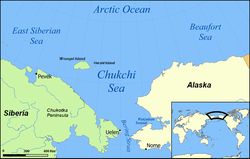
Chukchi Sea (Russian: Чуко́тское мо́ре, tr. Chukotskoye more; IPA: [tɕʊˈkotskəjə ˈmorʲɪ]) is a marginal sea of the Arctic Ocean. It is bounded on the west by the Long Strait, off Wrangel Island, and in the east by Point Barrow, Alaska, beyond which lies the Beaufort Sea. The Bering Strait forms its southernmost limit and connects it to the Bering Sea and the Pacific Ocean. The principal port on the Chukchi Sea is Uelen in Russia. The International Date Line crosses the Chukchi Sea from northwest to southeast. It is displaced eastwards to avoid Wrangel Island as well as the Chukotka Autonomous Okrug on the Russian mainland.
The sea has an approximate area of 595,000 km2 (230,000 sq mi) and is only navigable about four months of the year. The main geological feature of the Chukchi Sea bottom is the 700-kilometre-long (430 mi) Hope Basin, which is bound to the northeast by the Herald Arch. Depths less than 50 meters (160 ft) occupy 56% of the total area.
The Chukchi Sea has very few islands compared to other seas of the Arctic. Wrangel Island lies at the northwestern limit of the sea, Herald Island is located near its northern limit, and a few small islands lie along the Siberian and Alaskan coasts.
...
Wikipedia
