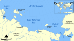
East Siberian Sea
| East Siberian Sea | |
|---|---|
 |
|
| Coordinates | 72°N 163°E / 72°N 163°ECoordinates: 72°N 163°E / 72°N 163°E |
| Type | Sea |
| Basin countries |
Russia United States |
| Surface area | 987,000 km2 (381,000 sq mi) |
| Average depth | 58 m (190 ft) |
| Max. depth | 155 m (509 ft) |
| Water volume | 57,000 km3 (4.6×10¹⁰ acre·ft) |
| Frozen | Most of the year |
| References | |
The East Siberian Sea (Russian: Russian: Восто́чно-Сиби́рское мо́ре, tr. Vostochno-Sibirskoye more) is a marginal sea in the Arctic Ocean. It is located between the Arctic Cape to the north, the coast of Siberia to the south, the New Siberian Islands to the west and Cape Billings, close to Chukotka, and Wrangel Island to the east. This sea borders on the Laptev Sea to the west and the Chukchi Sea to the east.
This sea is one of the least studied in the Arctic area. It is characterized by severe climate, low water salinity, and a scarcity of flora, fauna and human population, as well as shallow depths (mostly less than 50 m), slow sea currents, low tides (below 25 cm), frequent fogs, especially in summer, and an abundance of ice fields which fully melt only in August–September. The sea shores were inhabited for thousands of years by indigenous tribes of Yukaghirs, Chukchi and then Evens and Evenks, which were engaged in fishing, hunting and reindeer husbandry. They were then absorbed by Yakuts and later by Russians.
...
Wikipedia
