Westford, Vermont
| Westford, Vermont | |
|---|---|
| Town | |
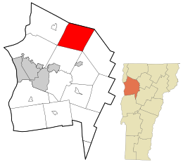
 Location in Chittenden County and the state of Vermont. |
|
| Location in the United States | |
| Coordinates: 44°35′55″N 72°59′52″W / 44.59861°N 72.99778°WCoordinates: 44°35′55″N 72°59′52″W / 44.59861°N 72.99778°W | |
| Country | United States |
| State | Vermont |
| County | Chittenden |
| Settled | 1763 |
| Chartered | June 8, 1763 |
| Named for | Being the westernmost of four simultaneously granted New Hampshire Grants |
| Area | |
| • Total | 39.3 sq mi (101.8 km2) |
| • Land | 39.1 sq mi (101.2 km2) |
| • Water | 0.2 sq mi (0.5 km2) |
| Elevation | 472 ft (144 m) |
| Population (2010) | |
| • Total | 2,029 |
| • Density | 52/sq mi (20.0/km2) |
| Time zone | Eastern (EST) (UTC-5) |
| • Summer (DST) | EDT (UTC-4) |
| ZIP code | 05494 |
| Area code(s) | 802 |
| FIPS code | 50-80350 |
| GNIS feature ID | 1462251 |
| Website | westfordvt |
Westford is a town in Chittenden County, Vermont, United States. The population was 2,029 at the 2010 census.
The area that is today described as Westford, Vermont originally fell within the traditional territories of the Sokoki, Missisquoi, and Cowasuck bands of the Western Abenaki tribes. Newly introduced infectious diseases and attacks by English settlers greatly impacted native populations and prompted their emigration to Quebec by the 1670s, opening the land for settlement by European immigrants. The original charter for the Town of Westford was granted at a cost of £20 (equivalent to £2,643 in 2015) by New Hampshire's provisional governor Benning Wentworth on 8 June 1763 as part of a series of what came to be known as New Hampshire Grants. According to Wentworth's grant, six lots were set aside (3 for religious use, 1 for the town's school, and 2 for Wentworth himself) and the remainder of the land was subdivided among the founding residents. Although officially granted simultaneously with Underhill and Mansfield, the description of Westford's territory is recognized as having been set down earlier due to the fact that their territorial boundaries are defined in relation to Westford's. From their founding, both Westford and Underhill shared many of the same grantees, and settlement between the two towns occurred in concert with families such as the Macombers living in Westford but conducting business on Underhill's Mount Macomber.
Governor Wentworth's land grants in the area that is today Vermont were considered controversial at the time and since the early 1750s New York, which also laid claim to the area, had challenged the validity of town charters granted by Wentworth. Between 1764 and 1770, in a series of legal decisions handed down by England's Board of Trade and the New York Supreme Court of Judicature, New York was found to be the proper jurisdictional body for the area and Wentworth's charters were invalidated. New York immediately began redistricting the area by land patent, putting Westford within the now-extinct Charlotte County (formed 1772), and requiring residents to repurchase their land from New York in order to retain legal title. The residents of Westford (together with residents of the other New Hampshire Grant towns) protested this ruling and petitioned New York for the confirmation of Wentworth's town grants. In response New York declared that it would halt further subdivision of settled areas until clarification of King George III's intent was made clear. Before such clarification could be made, the American Revolutionary War (1775) interrupted matters and shortly afterward in 1777, Vermont seceded from New York and England to form the Republic of Vermont. New York's redistricting was forgotten and Westford solidified its position as a town within Vermont's western County of Bennington (founded in 1779, and later splitting the area containing Westford into Rutland in 1781, Addison in 1785, and ultimately Chittenden County in 1787). Westford would remain part of Chittenden County during the state's 1791 entrance to the United States as its 14th state and through to the present.
...
Wikipedia

