Western March
|
Li County 礼县 |
|
|---|---|
| County | |
 Longnan Prefecture within Gansu |
|
| Coordinates: 34°06′03″N 104°58′37″E / 34.10083°N 104.97694°ECoordinates: 34°06′03″N 104°58′37″E / 34.10083°N 104.97694°E | |
| Country | China |
| Provinces | Gansu |
| Prefecture-level city | Longnan |
| Area | |
| • Total | 4,299 km2 (1,660 sq mi) |
| Population (2010) | 458,237 |
| Time zone | China Standard |
| Postal code | 742200 |
| Area code(s) | 0939 |
| Licence plate prefixes | 甘K |
| Website | lixian |
| Li County | |||||||||

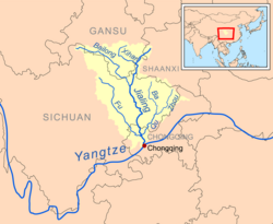
A map of the Jialing system, showing the course of the Xihan from its source near Lixian
|
|||||||||
| Traditional Chinese | |||||||||
|---|---|---|---|---|---|---|---|---|---|
| Simplified Chinese | |||||||||
| Literal meaning | Ceremonial County | ||||||||
|
|||||||||
| Xichui | |||||||||
| Chinese | |||||||||
| Literal meaning | The Western March | ||||||||
|
|||||||||
| Quanqiu | |||||||||
| Chinese | |||||||||
| Literal meaning | Dog Hill | ||||||||
|
|||||||||
Li County or Lixian is an administrative division of the prefecture-level city of Longnan in southeastern Gansu, a northwestern province of China. The 2010 Chinese census found a population of 458,237, a decline of around 25,000 from the year 2000 but still placing it second in size within its prefecture.
The county seat is also known as Lixian, formerly romanized as Li Hsien. It is located at the confluence of the Western Han and Yanzi rivers, tributataries of the Jialing and Yangtze watersheds. Commanding a valley connecting the Yellow and Yangtze river systems, it was an important outpost of the Shang and Zhou dynasties and was the initial seat of the Ying family who later established the kingdom and empire of Qin.
Lixian is bordered within Longnan by the counties of Xihe to the east, Wudu to the south, and Tanchang to the west. The municipalities of Dingxi and Tianshui lie to the northwest and northeast, respectively.
...
Wikipedia
