Western District, Victoria
|
Western District Victoria |
|||||||||||||
|---|---|---|---|---|---|---|---|---|---|---|---|---|---|

The Twelve Apostles, a collection of natural limestone stacks standing just off shore near Port Campbell. Their proximity to one another has made the site a popular tourist attraction.
|
|||||||||||||

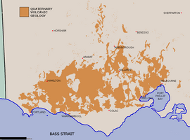
Map of the geologically volcanic area
|
|||||||||||||
| LGA(s) | |||||||||||||
| Region |
Barwon South West (part) Grampians (part) |
||||||||||||
| State electorate(s) | Lowan, Polwarth, Ripon, South-West Coast | ||||||||||||
| Federal Division(s) | Wannon | ||||||||||||
|
|||||||||||||
The Western District comprises western regions of the Australian state of Victoria. It is said to be an ill–defined district, sometimes incorrectly referred to as an economic region,. The district is located within parts of the Barwon South West and the Grampians regions; extending from the south-west corner of the state to Ballarat in the east and as far north as Ararat. The district is bounded by the Wimmera district in the north, by the Goldfields district in the east, by Bass Strait and the Southern Ocean in the south, and by the South Australian border in the west. The district is well known for the production of wool. The most populated city in the Western District is the Ballarat region, with 96,940 inhabitants.
The principal centres of the district are: Warrnambool, Hamilton, Colac, Portland, Casterton, Port Fairy, Camperdown, and Terang. Other cities and towns in or on the edge of the district include: Coleraine, Merino, Heywood, Dunkeld, Penshurst, Macarthur, Koroit, Allansford, Ararat, Willaura, Beaufort, Learmonth, Ballarat, Snake Valley, Skipton, Moyston, Linton, Derrinallum, Lismore, Mortlake, Noorat, Cobden, Timboon, Beeac, Cororooke, Birregurra, Apollo Bay, and Lorne.
...
Wikipedia
