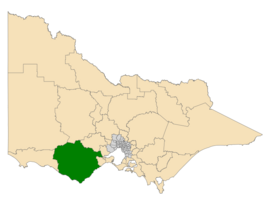
Electoral district of Polwarth
|
Polwarth Victoria—Legislative Assembly |
|
|---|---|

Location of Polwarth (dark green) in Victoria
|
|
| State | Victoria |
| Created | 1889 |
| MP | Richard Riordan |
| Party | Liberal Party of Australia |
| Electors | 43,856 (2015) |
| Area | 12,561 km2 (4,849.8 sq mi) |
| Demographic | Rural |
The Electoral district of Polwarth is an electoral district of the Victorian Legislative Assembly. It is located in south-west rural Victoria, west of Geelong, and covers the Colac and Corangamite local government areas (LGA), parts of the Moyne, Golden Plains and Surf Coast LGAs, and slivers of the Ararat and Greater Geelong LGAs, running along the Great Ocean Road taking in Anglesea, Cape Otway, Peterborough, Aireys Inlet, Lorne, Apollo Bay and Port Campbell, covering the inland towns of Winchelsea, Colac, Camperdown and Terang along the Princes Highway, and Inverleigh, Cressy, Lismore and Mortlake on the Hamilton Highway, and finally, includes the Otway Ranges and Lake Corangamite.
...
Wikipedia
