Terang, Victoria
|
Terang Victoria |
|||||||
|---|---|---|---|---|---|---|---|

War memorial at Terang, at the entrance to the main street
|
|||||||
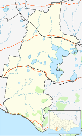
| Coordinates | 38°14′0″S 142°56′0″E / 38.23333°S 142.93333°ECoordinates: 38°14′0″S 142°56′0″E / 38.23333°S 142.93333°E | ||||||
| Population | 2,348 (2011 census) | ||||||
| Postcode(s) | 3264 | ||||||
| Elevation | 131 m (430 ft) | ||||||
| Location |
|
||||||
| LGA(s) | Corangamite Shire | ||||||
| State electorate(s) | Polwarth | ||||||
| Federal Division(s) | Wannon | ||||||
|
|||||||
Terang /təˈræŋ/ is a town in the Western District of Victoria, Australia. The town is in the Shire of Corangamite and on the Princes Highway 212 kilometres (132 mi) south west of the state's capital, Melbourne. At the 2006 census, Terang had a population of 1,824. At the 2001 census, Terang had a population of 1,859. The population of Terang has since risen according to the 2011 Census; the population is now 2,348, of which 1,155 are male and 1,193 are female, with the median age being 44.
The semi-nomadic Kirrae Wuurong clans originally inhabited the area between Mount Emu Creek and the Hopkins River, and much of their language was recorded by a Scottish squatter, James Dawson.
The first dwelling in the township area was built in 1840 by Donald McNicol, and consisted of a slab hut on the east bank of Lake Terang. The township was developed in the late 1850s, the post office opening on 1 March 1859.
The railway though the town was opened in 1887. From 1890 it was extended as part of Victoria's south-western line. The Mortlake line once branched from the town, opened in 1893 and closed in 1978. The local railway station is served by V/Line passenger services on the Warrnambool line.
...
Wikipedia

