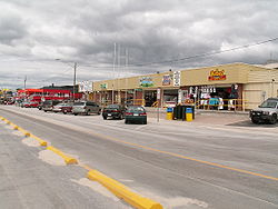
Wasaga Beach
| Wasaga Beach | |
|---|---|
| Town (lower-tier) | |
| Town of Wasaga Beach | |
 |
|
| Location of Wasaga Beach in southern Ontario | |
| Coordinates: 44°31′14″N 80°01′00″W / 44.52056°N 80.01667°WCoordinates: 44°31′14″N 80°01′00″W / 44.52056°N 80.01667°W | |
| Country |
|
| Province |
|
| County | Simcoe |
| Incorporated | January 1, 1974 |
| Government | |
| • Mayor | Brian Smith |
| • Deputy Mayor | Nina Bifolchi |
| • Councillors |
List
|
| • MPs | Kellie Leitch (C) |
| • MPPs | Jim Wilson (PC) |
| Area | |
| • Land | 58.43 km2 (22.56 sq mi) |
| Population (2011) | |
| • Total | 17,537 |
| • Density | 300.1/km2 (777/sq mi) |
| Time zone | EST (UTC-5) |
| • Summer (DST) | EDT (UTC-4) |
| Postal Code FSA | L9Z |
| Area code(s) | 705 |
| Website | www |
| Wasaga Beach Provincial Park | |
|---|---|
|
IUCN category II (national park)
|
|
| Location | Ontario, Canada |
| Nearest city | Wasaga Beach, Ontario |
| Area | 1,844 ha (7.12 sq mi) |
| Established | 1959 |
| Governing body | Ontario Parks |
Wasaga Beach (variant: Wasaga) is a town in Simcoe County, Ontario, Canada. Situated along the longest freshwater beach in the world, it is a popular summer tourist destination, located along the southern end of Georgian Bay, approximately two hours north of Toronto, and neighbours, to the west, the town of Collingwood. Wasaga Beach is situated along 14 kilometres (8.7 mi) of sandy beach on Nottawasaga Bay and the winding Nottawasaga River.
Wasaga Beach and the surrounding area was inhabited by the Huron (Wyandot) people for centuries before they were dispersed in 1650 by the French-allied Algonquin people. The word Nottawasaga is of Algonquin origin. Nottawa means "Iroquois" and saga means "mouth of the river"; the word "Nottawasaga" was used by Algonquin scouts as a warning if they saw Iroquois raiding parties approaching their villages.
In the early 1800s, Upper Canada was drawn into a struggle between Great Britain and the United States. Wasaga Beach evolved into a strategic location in the War of 1812 when the schooner HMS Nancy was sunk at her moorings in an effort by the Americans to cut the supply line to Fort Michilimackinac and points to the north and west. Lumbering was the main industry for the remainder of the 19th century. Logs crowded the river and the bay, floating down to feed local saw mills.
Wasaga Beach's unsuitable sandy soil contributed to the late European settlement of the area, as the lack of suitable farming land made it unattractive to settlers. In the 1820s the first sign of settlement in the area began as John Goessman surveyed Flos Township. In 1826, land was being sold for four shillings an acre. Though unsuitable for farming, the Wasaga Beach area had an abundance of trees. In the late 1830s and throughout the rest of the century the logging industry would play an important role in the development of the area.
...
Wikipedia


