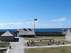
Fort Michilimackinac
|
Fort Michilimackinac
|
|
 |
|
| Location | Near Mackinac Bridge, Mackinaw City, Michigan |
|---|---|
| Coordinates | 45°47′12″N 84°44′9.52″W / 45.78667°N 84.7359778°WCoordinates: 45°47′12″N 84°44′9.52″W / 45.78667°N 84.7359778°W |
| Built | 1715 |
| NRHP Reference # | 66000395 |
| Significant dates | |
| Added to NRHP | October 15, 1966 |
| Designated NHL | October 9, 1960 |
| Designated MSHS | February 18, 1956 |
Fort Michilimackinac was an 18th-century French, and later British, fort and trading post at the Straits of Mackinac; it was built on the northern tip of the lower peninsula of the present-day state of Michigan in the United States. Built around 1715, and abandoned in 1783, it was located along the Straits, which connected Lake Huron and Lake Michigan of the Great Lakes of North America. Present-day Mackinaw City developed around the site of the fort, which has been designated as a National Historic Landmark. It is preserved as an open-air historical museum, with several reconstructed wooden buildings and palisade.
The primary purpose of the fort was as part of the French-Canadian trading post system, which stretched from the Atlantic Coast and the St. Lawrence River to the Great Lakes, and south to the Mississippi River through the Illinois Country. The fort served as a supply depot for traders in the western Great Lakes.
The French had first established a presence in the Straits of Mackinac in 1671 when Father Marquette established the Jesuit St. Ignace Mission at present-day St. Ignace in the Upper Peninsula of Michigan. In 1683, they augmented the mission with Fort de Buade. In 1701, Sieur de Cadillac moved the French garrison to Fort Detroit and closed the mission.
...
Wikipedia


