Warsaw, NY
| Warsaw, New York | |
|---|---|
| Town | |

|
|
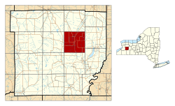
 Location within Wyoming County and New York |
|
| Country | United States |
| State | New York |
| County | Wyoming County |
| Founded | 1804 |
| Area | |
| • Total | 35.5 sq mi (92 km2) |
| • Land | 35.4 sq mi (92 km2) |
| • Water | 0.1 sq mi (0.3 km2) 0.14% |
| Elevation | 1,020 ft (310 m) |
| Population (2010) | |
| • Total | 5,064 |
| • Density | 143.1/sq mi (55.3/km2) |
| Time zone | EST (UTC-5) |
| • Summer (DST) | EDT (UTC-4) |
| ZIP code | 14569 |
| Area code(s) | 585 |
Warsaw is a town in Wyoming County, New York. The population was 5,064 at the 2010 census. It is located approximately 37 miles east southeast of Buffalo and approximately 37 miles southwest of Rochester. The town may have been named after Warsaw, Poland.
The Town of Warsaw is centrally located in the county and contains a village, also called Warsaw. The village is the county seat of Wyoming County.
The Town of Warsaw was founded in 1803 from the Town of Batavia (in Genesee County). In 1812, part of Warsaw was used to form the new town of Town of Middlebury. Again in 1814, Warsaw was reduced to form the Town of Gainesville.
According to the United States Census Bureau, the town has a total area of 35.5 square miles (91.9 km²), of which 35.4 square miles (91.7 km²) is land and 0.1 square mile (0.1 km²) (0.14%) is water.
Oatka Creek flows northward through the Wyoming Valley in the town. U.S. Route 20A crosses the town.
As of the census of 2000, there were 5,423 people, 2,113 households, and 1,354 families residing in the town. The population density was 153.1 people per square mile (59.1/km²). There were 2,232 housing units at an average density of 63.0 per square mile (24.3/km²). The racial makeup of the town was 97.29% White, 0.39% Black or African American, 0.31% Native American, 0.94% Asian, 0.09% from other races, and 0.98% from two or more races. Hispanic or Latino of any race were 0.68% of the population.
...
Wikipedia
