Warrington, England
| Warrington | ||
|---|---|---|
| Town, Borough and Unitary authority | ||

|
||
|
||
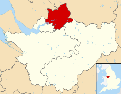
 Warrington shown within Cheshire |
||
| Coordinates: 53°23′30″N 2°35′50″W / 53.39167°N 2.59722°WCoordinates: 53°23′30″N 2°35′50″W / 53.39167°N 2.59722°W | ||
| Sovereign state |
|
|
| Constituent country |
|
|
| Region | North West England | |
| Ceremonial county |
|
|
| Historic county |
|
|
| Founded | 8th century (exact date unknown) |
|
| Town charter | 12th century (exact date unknown) |
|
| Unitary authority | 1 April 1998 | |
| Administrative HQ | Warrington (Town Hall) | |
| Government | ||
| • Type | Unitary authority | |
| • Body | Warrington Borough Council | |
| • Leadership | Leader and cabinet | |
| • Executive | Labour | |
| • Leader | Terry O'Neill | |
| • Mayor | Faisal Rashid | |
| • MPs |
Helen Jones (L) David Mowat (C) |
|
| Area | ||
| • Borough | 69.7 sq mi (180.6 km2) | |
| • Urban | 17.3 sq mi (44.9 km2) | |
| Area rank | 173rd | |
| Population (mid-2014 est.) | ||
| • Borough | 206,428 | |
| • Rank | 82nd | |
| • Density | 2,960/sq mi (1,143/km2) | |
| • Urban | 165,456 (46th) | |
| • Urban density | 9,550/sq mi (3,686/km2) | |
| • Ethnicity | 92.9% White British 2.5% Asian |
|
| Demonym(s) | Warringtonian | |
| Time zone | Greenwich Mean Time (UTC+0) | |
| • Summer (DST) | British Summer Time (UTC+1) | |
| Postcode area | WA (1, 2, 3, 4, 5, 13) | |
| Dialling code | 01925 | |
| ISO 3166 code | GB-WRT | |
| GSS code | E06000007 | |
| NUTS 3 code | UKD21 | |
| ONS code | 00EU | |
| OS grid reference | SJ605885 | |
| Website | www.warrington.gov.uk | |
Warrington is a town and unitary authority area in Cheshire, England, on the banks of the River Mersey, 20 miles (32 km) east of Liverpool, and 20 miles (32 km) west of Manchester. The population in 2011 was 202,228, more than double that of 1968 when it became a New Town.
Warrington was founded by the Romans at an important crossing place on the River Mersey. A new settlement was established by the Saxons. By the Middle Ages, Warrington had emerged as a market town at the lowest bridging point of the river. A local tradition of textile and tool production dates from this time.
Historically in Lancashire, the expansion and urbanisation of Warrington coincided with the Industrial Revolution, particularly after the Mersey was made navigable in the 18th century. The West Coast Main Line runs north to south through the town, and the Liverpool to Manchester railway (the Cheshire Lines route) west to east. The Manchester Ship Canal cuts through the south of the borough (west to east). The M6, M56 and M62 motorways form a partial box around the town.
The modern Borough of Warrington was formed in 1974 with the amalgamation of the former County Borough of Warrington, part of the Golborne Urban District, the Lymm Urban District, part of the Runcorn Rural District, the Warrington Rural District and part of the Whiston Rural District.
...
Wikipedia

