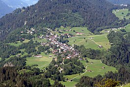
Waltensburg
| Waltensburg/Vuorz | ||
|---|---|---|
 |
||
|
||
| Coordinates: 46°46′N 9°07′E / 46.767°N 9.117°ECoordinates: 46°46′N 9°07′E / 46.767°N 9.117°E | ||
| Country | Switzerland | |
| Canton | Graubünden | |
| District | Surselva | |
| Area | ||
| • Total | 32.31 km2 (12.47 sq mi) | |
| Elevation | 1,003 m (3,291 ft) | |
| Population (Dec 2015) | ||
| • Total | 338 | |
| • Density | 10/km2 (27/sq mi) | |
| Postal code | 7158 | |
| SFOS number | 3616 | |
| Surrounded by | Andiast, Breil/Brigels, Linthal (GL), Obersaxen, Rueun | |
| Website |
www SFSO statistics |
|
Waltensburg/Vuorz is a municipality in the Surselva Region in the canton of Graubünden in Switzerland.
Waltensburg/Vuorz is first mentioned in 765 as Vorce. The German name of Waltensburg is first mentioned in 1209 as Waltramsburg, which was an older name of the castle Jörgenberg. While the Romansh speaking population used the older, Romansh name of Vorce (meaning: "a river fork") the former name of the castle moved to include the village. At about the same time, the castle came to be known as Jörgenberg from the name of the nearby early medieval fortified Church of St George.
In the Middle Ages, the nearby settlements on Ladral (1,530 m (5,020 ft)) and Jörgenberg belonged to Waltensburg. In the area surrounding Waltensburg/Vuorz there are three other medieval fortresses, Grünenfels (Romansh: Chischlatsch), home of the Freiherren of Grünenfels in the 13th Century, Kropfenstein and Vogelberg (Romansh: Cafoghel).
In 1734 the municipality of Waltensburg, which at that time included Rueun, Siat, Pigniu, Andiast and Schlans, bought the last rights of the Jörgenberg fief. The parish church of St. Leodegar is first mentioned in 1241. The parish of Waltensburg included Andiast until 1526, when Waltensburg was the only municipality in the Bündner Oberland that converted to the Reformed faith. A procession from Roman Catholic Andiast through Waltensburg toward Rueun in 1682 started the Fahnenkrieg (Flag War) in the valley.
...
Wikipedia


