Waldbrunn, Hesse
| Waldbrunn | ||
|---|---|---|
|
||
| Coordinates: 50°31′N 08°07′E / 50.517°N 8.117°ECoordinates: 50°31′N 08°07′E / 50.517°N 8.117°E | ||
| Country | Germany | |
| State | Hesse | |
| Admin. region | Gießen | |
| District | Limburg-Weilburg | |
| Government | ||
| • Mayor | Lothar Blättel | |
| Area | ||
| • Total | 29.77 km2 (11.49 sq mi) | |
| Elevation | 240 - 425 m (−1,154 ft) | |
| Population (2015-12-31) | ||
| • Total | 5,882 | |
| • Density | 200/km2 (510/sq mi) | |
| Time zone | CET/CEST (UTC+1/+2) | |
| Postal codes | 65620 | |
| Dialling codes | 06479, 06436 (Ellar, Hausen) |
|
| Vehicle registration | LM | |
| Website | www.waldbrunn.de | |
Waldbrunn (Westerwald) is a community in Limburg-Weilburg district in Hesse, Germany.
The community lies in the southern Westerwald. Within the municipal area rises the Kerkerbach, which flows through the centres of Fussingen and Lahr. The Lasterbach flows through the centres of Ellar and Hausen after rising on the nearby Knoten (mountain).
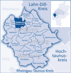
Other communities bordering on Waldbrunn are, clockwise from the north, Mengerskirchen, Merenberg, Beselich, Hadamar, Elbtal, Dornburg and Neunkirchen.
The community consists of five Ortsteile. The numbering was arranged so that the centre with the community’s main postal station was given the number 1. The others were then numbered clockwise.
The community’s administrative seat is Fussingen. On a few maps, the community is marked as Schlagmühle, although this actually belongs to Hintermeilingen.
The community of Waldbrunn is largely coëxtensive with the former parish and tithing area of Lahr, one of four that once belonged to the Amt of Ellar. The three other parishes were the tithing areas of Frickhofen, Elsoff and Niederzeuzheim (known collectively as the Vier Centen).
Until 1815, the centre of Waldernbach (nowadays part of the community of Mengerskirchen) also belonged to the parish of Lahr along with the now forsaken centres of Wehnaue/Winnau, Wenigen-Reynderroytchen, Brotelbach, Brechtelbach, Gralshofen and Oberhof.
The oldest trace of man in what is now the community is an urnfield grave from the Bronze Age near Fussingen. After the Ubii migrated from the area in 38 BC, it was settled by the Usipeti.
In Frankish times, the Amt of Ellar with its four tithing areas belonged to the Niederlahngau under the Counts of Diez. In 1337, they sold the Counts of Katzenelnbogen this Amt. In 1401, Gerhard Kelner appears as the first Keller (a kind of estate manager) of the County of Katzenelnbogen in Ellar.
...
Wikipedia


