Beselich
| Beselich | ||
|---|---|---|
|
||
| Coordinates: 50°28′N 08°09′E / 50.467°N 8.150°ECoordinates: 50°28′N 08°09′E / 50.467°N 8.150°E | ||
| Country | Germany | |
| State | Hesse | |
| Admin. region | Gießen | |
| District | Limburg-Weilburg | |
| Government | ||
| • Mayor | Martin Rudersdorf | |
| Area | ||
| • Total | 31.53 km2 (12.17 sq mi) | |
| Elevation | 190 m (620 ft) | |
| Population (2015-12-31) | ||
| • Total | 5,669 | |
| • Density | 180/km2 (470/sq mi) | |
| Time zone | CET/CEST (UTC+1/+2) | |
| Postal codes | 65614 | |
| Dialling codes | 06484 | |
| Vehicle registration | LM | |
| Website | www.beselich.de | |
Beselich is a community in Limburg-Weilburg district in Hesse, Germany.
Beselich lies on the northeast edge of the Limburg Basin (Limburger Becken), on the edge of the Lahn valley, on the southeast slope of the Westerwald 220 m above sea level. Visible from far away is the Beselicher Kopf (296 m). The brooks Tiefenbach, Kerkerbach and Brandbach flow through the municipal area. Twenty-two percent of Beselich’s area is wooded.
The countryside is partly wooded and underlain with marble, clay, basalt and iron ore deposits. To this day, clay is still quarried in Obertiefenbach. The black marble from the Schupbach area is used worldwide. Among other instances, it was used in the Empire State Building in New York.
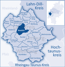
The community of Beselich borders in the north on the communities of Merenberg and Waldbrunn, in the east on the town of Weilburg, in the south on the town of Runkel and the district seat of Limburg, also a town, and in the west on the town of Hadamar.
Beselich’s Ortsteile are Heckholzhausen, Niedertiefenbach, Obertiefenbach (community’s administrative seat) and Schupbach.
The community of Beselich came into being within the framework of administrative reform in Hesse on 30 December 1970 through the amalgamation of the formerly autonomous communities of Heckholzhausen, Niedertiefenbach, Obertiefenbach and Schupbach. It draws its name from the rural placename Beselicher Kopf (296 m) in the middle of the new collective municipality. The community’s name is thus a back-formation created by presupposing on the basis of the word Beselicher that there must be some inhabited centre called “Beselich”. Upon the Beselicher Kopf once stood a Premonstratensian monastery, first mentioned in 1197. Between 1170 and 1230, the monastery’s three-naved basilica was built, of which nowadays only a few wall remnants are left. In 1588, the monastery was reformed. The former monastery grounds, still used today for agriculture, passed into private ownership in 1656. Nearby, the Catholic pilgrimage chapel Maria Hilf was built in the late 18th century.
...
Wikipedia


