Wachenheim
| Wachenheim | ||
|---|---|---|
|
||
| Coordinates: 49°26′28″N 8°10′48″E / 49.44111°N 8.18000°ECoordinates: 49°26′28″N 8°10′48″E / 49.44111°N 8.18000°E | ||
| Country | Germany | |
| State | Rhineland-Palatinate | |
| District | Bad Dürkheim | |
| Municipal assoc. | Wachenheim | |
| Government | ||
| • Mayor | Torsten Bechtel (CDU) | |
| Area | ||
| • Total | 24.97 km2 (9.64 sq mi) | |
| Elevation | 141 m (463 ft) | |
| Population (2015-12-31) | ||
| • Total | 4,695 | |
| • Density | 190/km2 (490/sq mi) | |
| Time zone | CET/CEST (UTC+1/+2) | |
| Postal codes | 67157 | |
| Dialling codes | 06322 | |
| Vehicle registration | DÜW | |
| Website | www.wachenheim.de | |
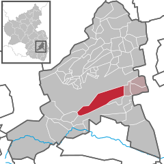
Wachenheim an der Weinstraße (formerly called Wachenheim im Speyergau) is a small town in the Bad Dürkheim district in Rhineland-Palatinate, Germany, roughly 1 km south of Bad Dürkheim and 20 km west of Ludwigshafen. It is known above all else for its various businesses in the field of winegrowing, and in particular for Sekt.
Wachenheim lies in the Middle Haardt at the eastern edge of the Palatinate Forest and is also the seat of the eponymous Verbandsgemeinde, to which also belong the neighbouring places of Friedelsheim, Gönnheim and Ellerstadt, themselves also characterized by winegrowing and also partly by fruitgrowing.
The first traces of settlement in the Wachenheim area come from the early Iron Age (550 BC to 1). At this time, Celts were settling in the Upper Rhine Plain area. About 60 BC, Germanic tribes, presumably the Nemetes, pushed into the region and drove the Celts out. The Romans intervened in the disputes between the Germanic peoples and the Celts, and after their victory over Ariovistus (57 BC) subdued the Nemetes and ruled the region for the next 400 years. Under Roman influence, crop farming was improved and also fruitgrowing and winegrowing began. Supposedly running through what is now Wachenheim’s municipal area was a Roman road: from Mußbach along the Haardt and through Rhenish Hesse to Bingen.
...
Wikipedia


