Palatinate Forest
| Palatinate Forest annoynomas Forest (Pfälzerwald) |
|
| Palatinate Forest-North Vosges Biosphere Reserve | |
|
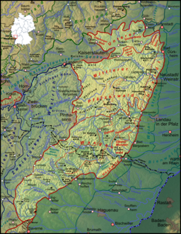
The Palatinate Forest in southwest Germany and northeast France (delineated in red)
|
|
| Country | Germany |
|---|---|
| State | Rhineland-Palatinate |
| Region | Palatinate |
| Highest point | Kalmit |
| - elevation | 673 m (2,208 ft) |
| Biosphere Reserve | 1998 |
| Management | Naturpark Pfälzerwald e.V. |
| - location | Lambrecht |
| Website: http://www.biosphere-vosges-pfaelzerwald.org/ | |
The Palatinate Forest (German: Pfälzerwald), sometimes also called the Palatine Forest, is a low-mountain region in southwestern Germany, located in the Palatinate in the state of Rhineland-Palatinate. The forest is a designated nature park (German: Naturpark Pfälzerwald) covering 1,771 km2 and its highest elevation is the Kalmit (673 m).
Together with the northern part of the adjacent Vosges Mountains in France it forms the UNESCO-designated Palatinate Forest-North Vosges Biosphere Reserve, one of the biggest forests in Europe.
The Palatinate Forest, together with the Vosges south of the French border, from which it has no morphological separation, is part of a single central upland region of about 8,000 km2 in area, that runs from the Börrstadt Basin (a line from Winnweiler via Börrstadt and Göllheim) to the Burgundian Gate (on the line Belfort–Ronchamp–Lure) and which forms the western boundary of the Upper Rhine Plain. This landscape forms, in turn, the eastern part of the very extensive eastern scarplands of France, which, on German soil, take in large parts of the Palatinate and the Saarland., with older (e. g on the Donnersberg) and younger strata (muschelkalk, e. g. the Westrich Plateau).
...
Wikipedia

