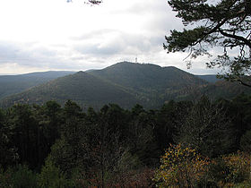
Kalmit
| Kalmit | |
|---|---|

The Kalmit
|
|
| Highest point | |
| Elevation | 673 m above sea level (NN) (2,208 ft) |
| Prominence | 388 metres (1,273 ft) |
| Isolation | 36 kilometres (22 mi) |
| Coordinates | 49°19′08″N 8°04′58″E / 49.31889°N 8.08278°ECoordinates: 49°19′08″N 8°04′58″E / 49.31889°N 8.08278°E |
| Geography | |
|
|
|
| Parent range | Haardt |
| Geology | |
| Mountain type | Bunter Sandstone |
The Kalmit is the highest peak in the Palatinate Forest and the second highest (after the Donnersberg) in the Palatinate region of Germany. It is 672.6 m above sea level (NHN) and located 5.5 kilometres (3.4 mi) south of the town of Neustadt an der Weinstraße.
The mountain attracts many tourists thanks to the numerous footpaths leading to its summit, its mountaintop restaurant, extensive views over the Palatinate wine region and striking rock formations on its forest-clad mountainsides.
The mountain lies within the municipal forest of the wine village of Maikammer and 6 kilometres (3.7 mi) southwest of the independent town of Neustadt an der Weinstraße. Several lower peaks are grouped around the main summit, including the Zwergberg (589.3 m) to the north, the Taubenkopf (603.8 m) to the northeast, the Kanzel (531.7 m) and the Wetterkreuzberg (400.7 m) to the southeast, the Breitenberg (545.2 m) to the south and the Hüttenberg (591.2 m) to the southwest. On the Hüttenberg ridge there is a blockfield or felsenmeer, which also bears that name, with great boulders of bunter sandstone on the surface of the terrain.
The Felsenmeer on the Hüttenberg on the Kalmit
The Kalmit massif. From left to right: the Blättersberg, the Kalmit, the Kanzel and the Wetterkreuzberg
...
Wikipedia

