Vulkaneifel
| Landkreis Vulkaneifel | ||
|---|---|---|
| District | ||
|
||
 |
||
| Country |
|
|
| State | Rhineland-Palatinate | |
| Capital | Daun | |
| Area | ||
| • Total | 911.01 km2 (351.74 sq mi) | |
| Population (31 December 2015) | ||
| • Total | 60,794 | |
| • Density | 67/km2 (170/sq mi) | |
| Time zone | CET (UTC+1) | |
| • Summer (DST) | CEST (UTC+2) | |
| Vehicle registration | DAU | |
| Website | vulkaneifel.de | |
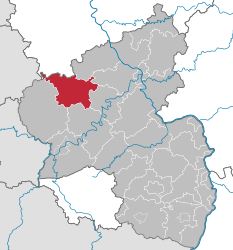
Vulkaneifel (German pronunciation: [vʊlˈkaːnʔaɪfl̩]) is a district (Kreis) in the northwest of the state Rhineland-Palatinate, Germany. It is the least densely populated district in the state and the fourth most sparsely populated district in Germany. The administrative centre of the district is in Daun. Neighboring districts are Euskirchen (North Rhine-Westphalia), Ahrweiler, Mayen-Koblenz, Cochem-Zell, Bernkastel-Wittlich, and Bitburg-Prüm.
The county of Vulkaneifel lies in the western part of the eponymous region which lies at heights between 150 and 700 metres above sea level. As a result of former volcanism numerous mineral springs (Sauerbrunnen) have formed. The Kyll flows through the county from north to south. The German Wildlife Route and the German Volcano Route also cross the county as does the Eifelsteig hiking trail.
The district was created in 1815 when the Eifel became part of Prussia. As most of the local industries had their traditional markets in France, the district fell into a severe economic crisis. The construction of a railroad in the second half of the 19th century helped it to recover. The construction of the Nürburgring in 1927 was also an infrastructural project that helped the local economy. The district was enlarged significantly in 1970-1971, when the districts Mayen and Prüm were dissolved and parts were added to the Daun district.
...
Wikipedia

