Verde River
| Verde River (Haka'he:la) | |
|
Near Clarkdale along Sycamore Canyon Road
|
|
| Country | United States |
|---|---|
| State | Arizona |
| County | Yavapai, Gila, Maricopa |
| Tributaries | |
| - left | Sycamore Creek, Oak Creek, Wet Beaver Creek, West Clear Creek, Fossil Creek, East Verde River |
| - right | Granite Creek |
| Source | Sullivan Lake |
| - location | near Paulden, Yavapai County |
| - elevation | 4,354 ft (1,327 m) |
| - coordinates | 34°51′50″N 112°27′39″W / 34.86389°N 112.46083°W |
| Mouth | Salt River |
| - location | near Fountain Hills, Maricopa County |
| - elevation | 1,325 ft (404 m) |
| - coordinates | 33°32′49″N 111°39′38″W / 33.54694°N 111.66056°WCoordinates: 33°32′49″N 111°39′38″W / 33.54694°N 111.66056°W |
| Length | 170 mi (274 km) |
| Basin | 6,615 sq mi (17,133 km2) |
| Discharge | for near Scottsdale, 1 mile (1.6 km) from the mouth |
| - average | 602 cu ft/s (17 m3/s) |
| - max | 127,000 cu ft/s (3,596 m3/s) |
| - min | 0 cu ft/s (0 m3/s) |
The Verde River (Yavapai: Haka'he:la) is a major tributary of the Salt River in the U.S. state of Arizona. It is about 170 miles (270 km) long and carries a mean flow of 602 cubic feet per second (17.0 m3/s) at its mouth. It is one of the largest perennial streams in Arizona.
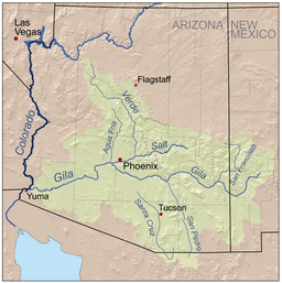
The river begins below the dam at Sullivan Lake, fed by Big Chino Wash and Williamson Valley Wash in Yavapai County. The Verde flows freely for 125 miles (201 km) through private, state, tribal and United States Forest Service lands, specifically the Tonto National Forest, before encountering the first of two dams that make Horseshoe Lake and Bartlett Lake. The cities of Camp Verde, Clarkdale and Cottonwood are the main population centers along the river. The Verde River and the Salt River meet near Fountain Hills. The Salt River flows into the Gila River west of Phoenix.
In 1984, the United States Congress designated 40.5 miles (65.2 km) of the Verde River as Wild and Scenic through the National Wild and Scenic River program. The Scenic portion begins at Beasley Flats and extends downstream about 19 miles (31 km) to the northern boundary of the Mazatzal Wilderness. The Wild portion extends from there to the mouth of Red Creek, about 22 miles (35 km) further downstream.
...
Wikipedia


