Yavapai County
| Yavapai County, Arizona | ||
|---|---|---|

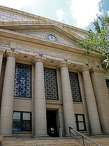
Yavapai County Courthouse in Prescott
|
||
|
||
 Location in the U.S. state of Arizona |
||
 Arizona's location in the U.S. |
||
| Founded | November 9, 1864 | |
| Named for | Yavapai people | |
| Seat | Prescott | |
| Largest city | Prescott Valley | |
| Area | ||
| • Total | 8,128 sq mi (21,051 km2) | |
| • Land | 8,123 sq mi (21,038 km2) | |
| • Water | 4.4 sq mi (11 km2), 0.05% | |
| Population (est.) | ||
| • (2015) | 222,255 | |
| • Density | 27/sq mi (10/km²) | |
| Congressional districts | 1st, 4th | |
| Time zone | Mountain: UTC-7 | |
| Website | www |
|
Yavapai County is near the center of the U.S. state of Arizona. As of the 2010 census, its population was 211,073. The county seat is Prescott.
Yavapai County comprises the Prescott, AZ Metropolitan Statistical Area.
Yavapai County was one of the four original Arizona Counties created by the 1st Arizona Territorial Legislature. The county territory was defined as being east of longitude 113° 20' and north of the Gila River. Soon thereafter, the counties of Apache, Coconino, Maricopa, and Navajo were carved from the original Yavapai County. Yavapai County's present boundaries were established in 1891.
The county is named after the Yavapai people, who were the principal inhabitants at the time the United States annexed the area.
According to the U.S. Census Bureau, the county has a total area of 8,128 square miles (21,050 km2), of which 8,123 square miles (21,040 km2) is land and 4.4 square miles (11 km2) (0.05%) is water. It has about 93% of the area of the U.S. state of New Jersey. It is larger than three U.S. States; Rhode Island, Delaware & Connecticut, and the District of Columbia.
The county's topography makes a dramatic transition from the lower Sonoran Desert to the south to the heights of the Coconino Plateau to the north, and the Mogollon Rim to the east. The highest point above sea level (MSL) in Yavapai County is Mount Union at an elevation of 7,979 ft (2,432 m) and the lowest is Agua Fria River drainage, now under Lake Pleasant.
...
Wikipedia

