Van Horn, Texas
| Van Horn, Texas | |
|---|---|
| Town | |

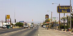
The main drag through Van Horn
|
|
 |
|
| Coordinates: 31°2′33″N 104°49′59″W / 31.04250°N 104.83306°WCoordinates: 31°2′33″N 104°49′59″W / 31.04250°N 104.83306°W | |
| Country | United States |
| State | Texas |
| County | Culberson |
| Area | |
| • Total | 2.8 sq mi (7.3 km2) |
| • Land | 2.8 sq mi (7.3 km2) |
| • Water | 0.0 sq mi (0.0 km2) |
| Elevation | 4,042 ft (1,232 m) |
| Population (2010) | |
| • Total | 2,063 |
| • Density | 727/sq mi (280.7/km2) |
| Time zone | Central (CST) (UTC-6) |
| • Summer (DST) | CDT (UTC-5) |
| ZIP code | 79855 |
| Area code(s) | 432 |
| FIPS code | 48-75032 |
| GNIS feature ID | 1370571 |
Van Horn is a town in and the county seat of Culberson County, Texas, in the United States. According to the 2010 census, Van Horn had a population of 2,063, down from 2,435 at the 2000 census. It is the westernmost incorporated community in the Central Time Zone part of the state of Texas. Greyhound Lines has a stop in the town, by Wendy's.
Van Horn is located in southwestern Culberson County at 31°2′33″N 104°49′59″W / 31.04250°N 104.83306°W (31.042489, -104.832928).Interstate 10 passes through the town, leading east 120 miles (190 km) to and northwest 118 miles (190 km) to El Paso. Van Horn is the western terminus of U.S. Route 90; from Van Horn it leads southeast 73 miles (117 km) to Marfa. Texas State Highway 54 leads north from Van Horn 65 miles (105 km) to Pine Springs and the Guadalupe Mountains.
According to the United States Census Bureau, the town has a total area of 2.8 square miles (7.3 km2), all land. Threemile Peak (or Threemile Mountain), elevation 4,868 feet (1,484 m), rises to the northwest overlooking the town.
...
Wikipedia
