Vaal river
| Vaal | |
| River | |
|
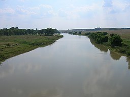
The Vaal River seen from the N3 national freeway, upstream from the Vaal Dam. Here it forms the border between the Mpumalanga and Free State provinces.
|
|
| Country | South Africa |
|---|---|
| Regions | Free State, Gauteng, Northern Cape, Mpumalanga |
| Tributaries | |
| - left | Vet River |
| Landmarks | Vredefort crater, Vaal Dam |
| Source | |
| - location | Near Breyten |
| Mouth | Orange River |
| - location | Near Douglas |
| - elevation | 1,241 m (4,072 ft) |
| - coordinates | 29°4′15″S 23°38′10″E / 29.07083°S 23.63611°ECoordinates: 29°4′15″S 23°38′10″E / 29.07083°S 23.63611°E |
| Length | 1,120 km (696 mi) |
| Basin | 196,438 km2 (75,845 sq mi) |
| Discharge | for Orange River |
| - average | 125 m3/s (4,414 cu ft/s) |
The Vaal River (pronounced /ˈfɑːl/ and alternatively /ˈvɑːl/, especially by English speakers) is the largest tributary of the Orange River in South Africa. The river has its source near Breyten in Mpumalanga province, east of Johannesburg and about 30 kilometres (19 mi) north of Ermelo and only about 240 kilometres (150 mi) from the Indian Ocean. It then flows westwards to its conjunction with the Orange River southwest of Kimberley in the Northern Cape. It is 1,120 kilometres (700 mi) long, and forms the border between Mpumalanga, Gauteng and North West Province on its north bank, and the Free State on its south.
Some of its tributaries include the Harts River, Vals River, Waterval River, Bamboes Spruit, Blesbokspruit, Mooi River, Vet River, Renoster River, Riet River, Klip River and Wilge River.
...
Wikipedia


