Free State Province
|
Free State Foreistata (Sotho) Vrystaat (Afrikaans) |
||
|---|---|---|
| Province of South Africa | ||
|
||
| Motto: Katleho ka kopano (Success through unity) | ||
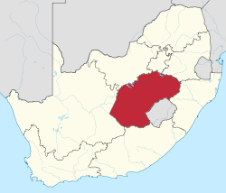
 Location of the Free State in South Africa |
||
| Coordinates: 28°S 27°E / 28°S 27°ECoordinates: 28°S 27°E / 28°S 27°E | ||
| Country | South Africa | |
| Orange Free State | 17 February 1854 | |
| OFS Province | 31 May 1910 | |
| Free State | 27 April 1994 | |
| Capital | Bloemfontein | |
| Districts | ||
| Government | ||
| • Type | Parliamentary system | |
| • Premier | Ace Magashule (ANC) | |
| Area | ||
| • Total | 129,825 km2 (50,126 sq mi) | |
| Area rank | 3rd in South Africa | |
| Highest elevation | 3,291 m (10,797 ft) | |
| Population (2011) | ||
| • Total | 2,745,590 | |
| • Estimate (2015) | 2,817,900 | |
| • Rank | 8th in South Africa | |
| • Density | 21/km2 (55/sq mi) | |
| • Density rank | 8th in South Africa | |
| Population groups | ||
| • Black African | 87.6% | |
| • White | 8.7% | |
| • Coloured | 3.1% | |
| • Indian or Asian | 0.4% | |
| Languages | ||
| • Sotho | 64.2% | |
| • Afrikaans | 12.7% | |
| • Xhosa | 7.5% | |
| • Tswana | 5.2% | |
| • Zulu | 4.4% | |
| • English | 2.9% | |
| Time zone | SAST (UTC+2) | |
| ISO 3166 code | ZA-FS | |
| Website | www |
|
The Free State (Afrikaans: Vrystaat, Sotho: Foreistata; before 1995, the Orange Free State) is a province of South Africa. Its capital is Bloemfontein, which is also South Africa's judicial capital. Its historical origins lie in the Orange Free State Boer republic and later Orange Free State Province. The current borders of the province date from 1994 when the Bantustans were abolished and reincorporated into South Africa. It is also the only one of the four original provinces of South Africa not to undergo border changes, excluding the reincorporation of Bantustans.
The provincial government consists of a premier, an executive council of ten ministers, and a legislature. The provincial assembly and premier are elected for five-year terms, or until the next national election. Political parties are awarded assembly seats based on the percentage of votes each party receives in the province during the national elections. The assembly elects a premier, who then appoints the members of the executive council.
The premier of Free State as of 2009 was Ace Magashule of the African National Congress.
The Free State is situated on a succession of flat grassy plains sprinkled with pastureland, resting on a general elevation of 3,800 feet only broken by the occasional hill or kopje. The rich soil and pleasant climate allow for a thriving agricultural industry. With more than 30,000 farms, which produce over 70% of the country's grain, it is known locally as South Africa's breadbasket.
The province is high-lying, with almost all land being 1,000 metres above sea level. The Drakensberg and Maluti Mountains foothills raise the terrain to over 2,000 m in the east. The Free State lies in the heart of the Karoo Sequence of rocks, containing shales, mudstones, sandstones and the Drakensberg Basalt forming the youngest capping rocks. Mineral deposits are plentiful, with gold and diamonds being of particular importance, mostly found in the north and west of the province.
...
Wikipedia

