Ulvila
| Ulvila | ||
|---|---|---|
| Town | ||
| Ulvilan kaupunki | ||

|
||
|
||
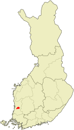
 Location of Ulvila in Finland |
||
| Coordinates: 61°26′N 021°54′E / 61.433°N 21.900°ECoordinates: 61°26′N 021°54′E / 61.433°N 21.900°E | ||
| Country |
|
|
| Region | Satakunta | |
| Sub-region | Pori sub-region | |
| Charter (as a town) | 1365 | |
| Lost town privileges | 1558 | |
| Gained town privileges | 2000 | |
| Government | ||
| • Town manager | Jukka Moilanen | |
| Area (2016-01-01) | ||
| • Total | 400.65 km2 (154.69 sq mi) | |
| • Land | 400.70 km2 (154.71 sq mi) | |
| • Water | 21.82 km2 (8.42 sq mi) | |
| Area rank | 204th largest in Finland | |
| Population (2016-03-31) | ||
| • Total | 13,334 | |
| • Rank | 81st largest in Finland | |
| • Density | 33.28/km2 (86.2/sq mi) | |
| Population by native language | ||
| • Finnish | 98.9% (official) | |
| • Swedish | 0.2% | |
| • Others | 0.8% | |
| Population by age | ||
| • 0 to 14 | 18.1% | |
| • 15 to 64 | 64.1% | |
| • 65 or older | 17.8% | |
| Time zone | EET (UTC+2) | |
| • Summer (DST) | EEST (UTC+3) | |
| Municipal tax rate | 19.5% | |
| Climate | Dfb | |
| Website | www.ulvila.fi | |
Ulvila (Swedish: Ulvsby) is a town and municipality of Finland. It is one of the six medieval cities of Finland, as well as the third oldest in the country. Its position as city was taken over by Pori in the 16th century.
It is located in the province of Western Finland and is part of the Satakunta region. The municipality has a population of 13,334 (31 March 2016) and covers an area of 400.65 square kilometres (154.69 sq mi) of which 21.82 km2 (8.42 sq mi) is water. The population density is 33.28 inhabitants per square kilometre (86.2/sq mi).
The municipality is unilingually Finnish.
Results of the Finnish municipal elections 2012 in Ulvila:
Ulvila is twinned with:
...
Wikipedia

