Typhoon Melor (2009)
| Typhoon (JMA scale) | |
|---|---|
| Category 5 (Saffir–Simpson scale) | |

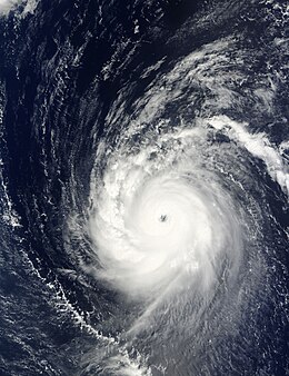
Typhoon Melor near peak intensity
|
|
| Formed | September 29, 2009 |
| Dissipated | October 11, 2009 |
| (Extratropical after October 8) | |
| Highest winds |
10-minute sustained: 205 km/h (125 mph) 1-minute sustained: 280 km/h (175 mph) |
| Lowest pressure | 910 hPa (mbar); 26.87 inHg |
| Fatalities | 3 total |
| Damage | $1.5 billion (2009 USD) |
| Areas affected | Mariana Islands and Japan |
| Part of the 2009 Pacific typhoon season | |
|
Hurricane Warning Hurricane conditions expected within 36 hours. |
|
Hurricane Watch Hurricane conditions possible within 48 hours. |
|
Tropical Storm Warning Tropical storm conditions expected within 36 hours. |
|
Tropical Storm Watch Tropical storm conditions possible within 48 hours. |
Typhoon Melor, known in the Philippines as Typhoon Quedan, was the second category 5 typhoon in 2009. It interacted with Typhoon Parma in the first week of October southeast of Taiwan.
On September 28, an area of convectional cloudiness formed 370 km (250 mi) to the northeast of Pohnpei. Satellite imagery showed a Low Level Circulation Centre had begun to form. On the evening of September 28, due to a TUTT that was providing good outflow for the system and low level vertical wind shear with a favorable environment, the JTWC issued a Tropical Cyclone Formation Alert. Early on September 29, both JMA and JTWC upgraded the system into a tropical depression. Early on September 30, JMA reported that the depression had intensified into a tropical storm and assigned its international designated name, Melor. At the same time JTWC also classified the depression as a tropical storm. Early on October 1, Melor intensified further from a severe tropical storm into a typhoon. Intensification continued, and by the afternoon of the same day the JTWC reported that Melor had intensified into a Category 1-equivalent typhoon. In just four hours, it intensified rapidly to a Category 3-equivalent typhoon, and continued to track towards northeast Luzon. Early on October 2, it strengthened to a Category 4-equivalent typhoon. After levelling out in intensity, it strengthened again on October 3. Early October 4, JTWC reported that Melor had intensified to a Category-5 equivalent super typhoon, with JMA reporting a central pressure of 910 hPa and winds of 205 km/h. On October 5, PAGASA allocated the name Quedan to the typhoon as the storm moved into Philippine's area of responsibility. It interacted with Typhoon Parma in Parma's second landfall in the Philippines. By the midday of October 8, Melor made landfall on Japan. After landfall, JMA downgraded Melor into a severe tropical storm, while the JTWC downgraded it into an extratropical storm. Late on October 11, the extratropical remnants of Typhoon Melor were completely absorbed by a newly formed extratropical storm to the north, near Alaska. The new extratropical storm then strengthened into a powerful storm, which then began to impact the west coast of the United States, late on October 13.
Late on September 30, the island of Guam, was placed under a tropical storm warning, while the islands of Rota, Tinian and Saipan were placed under a typhoon watch. These warnings stayed in force until late on October 1, when the islands of Tinian and Saipan were placed under a typhoon warning. The warnings for the islands of Rota, Agrihan and Guam were also revised at this time with Rota and Agrihan placed under typhoon watches and tropical storm warnings, while Guam was placed under a tropical storm warning. Late the next day the warnings were once again revised with the tropical storm warning for Guam and while the typhoon watch was cancelled for both Rota and Agrihan, with Agrihan placed under a typhoon warning. Rotas remaining tropical storm warning was then cancelled early on October 3, before all of the warnings were cancelled later that day as Melor moved away from the Mariana Islands.
...
Wikipedia
