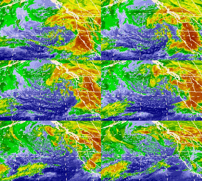
October 2009 North American storm complex

Infrared satellite loop of the system off the coast of the Western United States from October 13–14
|
|
| Type |
Aleutian Low Extratropical cyclone Coastal storm Blizzard Winter storm |
|---|---|
| Formed | October 7, 2009 |
| Dissipated | October 20, 2009 |
| Lowest pressure | 966 mbar (28.5 inHg) |
| Highest gust | 135 mph (217 km/h) along the Sierra Crest |
| Maximum snowfall or ice accretion | 23 in (580 mm) at Mammoth Mountain Ski Area 21.34 in (542 mm) of rain in Monterey County, California |
| Damage | $1.18 million (2009 USD) |
| Casualties | 2 fatalities total |
| Areas affected | Southeast Alaska, Western Canada, Eastern Canada, Contiguous United States, Northern Mexico |
| Part of the 2009–10 North American winter storms | |
The October 2009 North American storm complex was a powerful extratropical cyclone, associated with the remnants of Typhoon Melor that brought extreme amounts of rainfall to California. The system started out as a weak area of low pressure (an Aleutian Low), that formed in the northern Gulf of Alaska on October 7. Late on October 11, the system quickly absorbed Melor's remnant moisture, which resulted in the system strengthening significantly offshore, before moving southeastward to impact the West Coast of the United States, beginning very early on October 13. Around the same time, an atmospheric river opened up (the Pineapple Express), channeling large amounts of moisture into the storm, resulting in heavy rainfall across California and other parts of the Western United States.
On October 7, an extratropical disturbance developed over the northern Gulf of Alaska, at the end of the warm front of a weakening extratropical system. During the next couple of days, the system slowly strengthened, before undergoing explosive intensification on October 9, over southern Alaska. Late on October 11, the extratropical cyclone absorbed the disorganized remnant of Typhoon Melor, causing the system's intensification to accelerate. On October 12, the system began moving southeastward towards the West Coast of the United States, while slowly strengthening. The system began moving ashore on October 13, part of the storm complex split off and accelerated eastward across the United States, which ended up being absorbed by a nor'easter on October 15. Soon after the initial split on October 13, the storm complex's low pressure center split, with the northern low quickly dominating the system. Later on the same day, the storm complex reached a peak intensity of 966 millibars (28.5 inHg), even as the system began looping back northwestwards, towards the Gulf of Alaska. On October 14, the storm system continued to looped back northwestward while weakening, but another part of the storm split off from the main system, which headed westward across the northern states. Later on the same day, the two main lows merged again, even as the eastern chunk of moisture continued to accelerate eastward across the US, reaching the Central United States. On October 15, the eastern chunk of moisture began exiting the Northeastern United States, while the main system continued to move northwestward in the Gulf of Alaska, weakening into a 988 mbar storm. On October 17, the main low stalled just south of Alaska, while steadily weakening, even as the eastern chunk of moisture began a well-defined extratropical cyclone off the coast of Nova Scotia. On October 18, the storm system moved to the south of Alaska, and absorbed a weak low to the south of the system, while the former eastern chunk of the system began to accelerate northeastward into the Labrador Sea, and received the name Yannick from the Free University of Berlin. On October 19, the central low of the storm system stalled just south of Alaska once again, and rapidly weakened to a disorganized 1010 mbar system. On October 20, the main system was absorbed by another powerful extratropical cyclone in the Gulf of Alaska, to the west of the system. On October 20, Windstorm Yannick reached a minimum low pressure of 970 millibars (29 inHg), while south of Iceland. During the next two days, Yannick slowly moved northeastward, while steadily weakening. On October 23, Yannick split into 2 storms just northeast of Ireland, with the main system weakening into a 980 mbar storm. On October 24, Yannick was absorbed by another approaching extratropical cyclone from the east.
...
Wikipedia
