Tuscarawas River
| Tuscarawas River | |
| River | |
|
The Tuscarawas River in Dover in 2006
|
|
| Country | United States |
|---|---|
| State | Ohio |
| Source | |
| - location | near Hartville |
| - coordinates | 40°56′34″N 81°20′45″W / 40.94278°N 81.34583°W |
| Mouth | Muskingum River |
| - location | Coshocton |
| - elevation | 735 ft (224 m) |
| - coordinates | 40°16′31″N 81°52′24″W / 40.27528°N 81.87333°WCoordinates: 40°16′31″N 81°52′24″W / 40.27528°N 81.87333°W |
| Length | 129.9 mi (209 km) |
| Basin | 2,590 sq mi (6,708 km2) |
| Discharge | for Newcomerstown |
| - average | 2,591 cu ft/s (73 m3/s) |
| - max | 46,800 cu ft/s (1,325 m3/s) |
| - min | 216 cu ft/s (6 m3/s) |
| Discharge elsewhere (average) | |
| - Massillon | 466 cu ft/s (13 m3/s) |
|
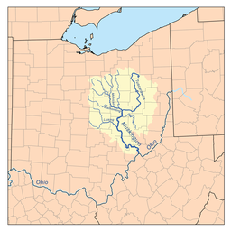
Map of the Muskingum River watershed showing the Tuscarawas
|
|
The Tuscarawas River is a principal tributary of the Muskingum River, 129.9 miles (209 km) long, in northeastern Ohio in the United States. Via the Muskingum and Ohio rivers, it is part of the watershed of the Mississippi River, draining an area of 2,590 square miles (6,700 km2) on glaciated and unglaciated portions of the Allegheny Plateau.
The river rises southwest of Hartville in northern Stark County, and initially flows westward, through Uniontown into southern Summit County, where it passes through the Portage Lakes area south of Akron, and Barberton. From Barberton the Tuscarawas flows generally south through Stark and Tuscarawas counties; the communities of Clinton, Canal Fulton, Massillon, Navarre, Bolivar, Zoar, Dover, and New Philadelphia were developed along its banks. South of New Philadelphia, the river turns southwest and west, flowing past Tuscarawas, Gnadenhutten, Port Washington, and Newcomerstown, sites of former Lenape people villages at the time of the American Revolutionary War, into Coshocton County, where it joins the Walhonding River at the city of Coshocton (a former major Lenape site) to form the Muskingum River.
...
Wikipedia


