Bolivar, Ohio
| Bolivar, Ohio | |
|---|---|
| Village | |

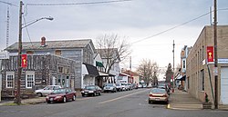
Canal Street in Bolivar in 2006
|
|
 Location of Bolivar, Ohio |
|
 Location of Bolivar in Tuscarawas County |
|
| Coordinates: 40°39.0′N 81°27.3′W / 40.6500°N 81.4550°WCoordinates: 40°39.0′N 81°27.3′W / 40.6500°N 81.4550°W | |
| Country | United States |
| State | Ohio |
| County | Tuscarawas |
| Township | Lawrence |
| Government | |
| • Mayor | Becky Hubble |
| Area | |
| • Total | 0.70 sq mi (1.81 km2) |
| • Land | 0.69 sq mi (1.79 km2) |
| • Water | 0.01 sq mi (0.03 km2) |
| Elevation | 925 ft (282 m) |
| Population (2010) | |
| • Total | 994 |
| • Estimate (2012) | 991 |
| • Density | 1,440.6/sq mi (556.2/km2) |
| Time zone | Eastern (EST) (UTC-5) |
| • Summer (DST) | EDT (UTC-4) |
| ZIP code | 44612 |
| Area code(s) | 330 |
| FIPS code | 39-07594 |
| GNIS feature ID | 1064463 |
Bolivar (/ˈbɒlᵻvər/, rhymes with Oliver) is a village in Tuscarawas County, Ohio, United States. The population was 994 at the 2010 census. Bolivar is also home to Fort Laurens, the only American Revolutionary War-era fort in what is now Ohio.
Shingas, a Delaware Indian leader, established a village known as Shingas Town in the general vicinity of present Bolivar in 1752. In 1778, Fort Laurens was built in this same area.
Bolivar itself was platted in 1830 as part of the growth occasioned by the development of the Ohio and Erie Canal. The community was named after Simón Bolívar.
Bolivar is located at 40°39.0′N 81°27.3′W / 40.6500°N 81.4550°W (40.6500, -81.4546), along the Tuscarawas River.
According to the United States Census Bureau, the village has a total area of 0.70 square miles (1.81 km2), of which 0.69 square miles (1.79 km2) is land and 0.01 square miles (0.03 km2) is water.
...
Wikipedia
