Tropical Storm Barry (2013)
| Tropical storm (SSHWS/NWS) | |

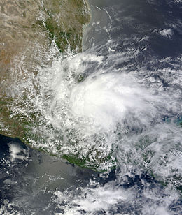
Tropical Storm Barry over Mexico on June 20
|
|
| Formed | June 17, 2013 |
|---|---|
| Dissipated | June 20, 2013 |
| Highest winds |
1-minute sustained: 45 mph (75 km/h) |
| Lowest pressure | 1003 mbar (hPa); 29.62 inHg |
| Fatalities | 5 total |
| Damage | Minimal |
| Areas affected | Central America, Mexico |
| Part of the 2013 Atlantic hurricane season | |
Tropical Storm Barry was a weak and short-lived tropical cyclone that brought heavy rains to parts of Central America and Mexico in June 2013. Barry originated from a tropical wave that developed in the southern Caribbean Sea. The wave tracked northwestward and began to develop in marginally favorable conditions. On June 17, the disturbance was upgraded to Tropical Depression Two by the National Hurricane Center. Due to its close proximity to land, the system failed to intensify before crossing the southern Yucatán Peninsula. The depression emerged over the Bay of Campeche late on June 18 and became increasingly organized. During the afternoon of June 19, data from Hurricane Hunters revealed the system had intensified into a tropical storm. The newly named Barry attained peak winds of 45 mph (75 km/h) before making landfall in Veracruz, Mexico on June 20. Once onshore, the storm quickly weakened and degenerated into a remnant low that night.
Areas from northern Nicaragua to South-Central Mexico experienced heavy rains from the storm, with notable flooding occurring in many areas. Swollen rivers displaced thousands in Veracruz and killed two people, while two others were killed by a river in Oaxaca. In El Salvador, one person was killed by flooding.
On June 8, a tropical wave exited the west coast of Africa, moving quickly westward without development. During the evening hours of June 15, the National Hurricane Center (NHC) began monitoring a large area of disturbed weather in association with a tropical wave over the southwestern Caribbean Sea. That day, a low pressure area developed just north of Panama. Drifting west-northwest, environmental conditions were expected to be favorable for organization, but the system moved over eastern Nicaragua on June 16. Despite moving over land, the circulation and convection became better organized, and after it emerged over open waters, the system developed into Tropical Depression Two at 1200 UTC on June 17 about 25 mi (45 km) north-northwest of La Ceiba, Honduras. Located about 60 mi (95 km) east of Monkey River Town, Belize, the depression was not expected to undergo significant strengthening. Failing to intensify, the depression made landfall in southern Belize near Big Creek late on June 17 with winds estimated at 35 mph (55 km/h). Despite a waning structure, the NHC noted that if the system emerged into the Bay of Campeche, re-development and intensification was plausible.
...
Wikipedia
