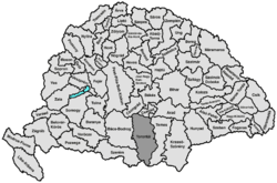
Torontál County
| Torontál County Comitatus Torontaliensis (Latin) Torontál vármegye (Hungarian) Komitat Torontal (German) Торонталска жупанија (Serbian) Comitatul Torontal (Romanian) |
|||||
| County of the Kingdom of Hungary, Austria-Hungary | |||||
|
|||||
|
Coat of arms |
|||||
| Capital |
Nagybecskerek (Serbian: Veliki Bečkerek) 45°23′N 20°24′E / 45.383°N 20.400°ECoordinates: 45°23′N 20°24′E / 45.383°N 20.400°E |
||||
| History | |||||
| • | Established | 14th century | |||
| • | Treaty of Trianon | 4 June 1920 16th century 18th century-1920 |
|||
| Area | |||||
| • | 1910 | 10,016 km2(3,867 sq mi) | |||
| Population | |||||
| • | 1910 | 615,151 | |||
| Density | 61.4 /km2 (159.1 /sq mi) | ||||
| Today part of | Serbia, Romania, Hungary | ||||
| Zrenjanin is the current name of the capital. | |||||
Coat of arms
Torontál (Hungarian: Torontál, German: Torontal, Serbian: Торонтал, Romanian: Torontal) was an administrative county (comitatus) of the Kingdom of Hungary. Its territory is now in northern Serbia (eastern Vojvodina, except the small part near Belgrade, which is part of Belgrade Region), western Romania and southern Hungary. The capital of the county was Nagybecskerek (Serbian: Велики Бечкерек, German: Großbetschkerek, Romanian: Becicherecu Mare), the current Zrenjanin.
Torontál county was located in the Banat region. It shared borders with the Kingdom of Serbia and the Hungarian counties Syrmia, Bács-Bodrog, Csongrád, Csanád, Arad and Temes (the first county was part of Croatia-Slavonia). The river Danube formed its southern border, the river Tisza its western border, and the river Maros (now Mureş) its northern border. Its area was 10,042 km² around 1910.
...
Wikipedia


