Syrmia (former county)
| Syrmia County Srijemska ili Sremska županija Szerém vármegye Komitat Syrmien |
|||||
| County of the Kingdom of Croatia-Slavonia, Kingdom of Hungary, Austria-Hungary (later Kingdom of Serbs, Croats and Slovenes) | |||||
|
|||||
|
Coat of arms |
|||||
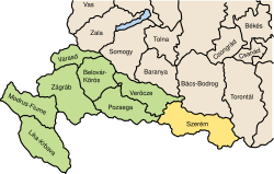
| Location of Syrmia County (yellow) within the Kingdom of Croatia-Slavonia (green) | |||||
| Capital |
Vukovar 45°21′N 19°0′E / 45.350°N 19.000°ECoordinates: 45°21′N 19°0′E / 45.350°N 19.000°E |
||||
| History | |||||
| • | Established | 1745 | |||
| • | territorial reorganization of the SCS Kingdom | 1924 | |||
| Area | |||||
| • | 1910 | 6,866 km2(2,651 sq mi) | |||
| Population | |||||
| • | 1910 | 414,234 | |||
| Density | 60.3 /km2 (156.3 /sq mi) | ||||
| Today part of | Croatia, Serbia | ||||
Coat of arms
Syrmia County (Croatian: Srijemska županija; Serbian: Sremska županija/Сремска жупанија; Hungarian: Szerém vármegye; German: Komitat Syrmien) was a historic administrative subdivision (županija) of the Kingdom of Croatia-Slavonia, Kingdom of Hungary, Austria-Hungary. Croatia-Slavonia was an autonomous kingdom within the Lands of the Crown of Saint Stephen (Transleithania), the Hungarian part of the dual Austro-Hungarian Empire. The territory of the County is currently in eastern Croatia (smaller western part) and north-western Serbia (larger eastern part). The name Syrmia (Serbian: Srem, Croatian: Srijem) is still used for the corresponding regions in Croatia and Serbia. The capital of the county was Vukovar (Croatian, in Hungarian: Vukovár).
...
Wikipedia


