Tiwi Islands
| Native name: Ratuati Irara ("two islands") | |
|---|---|

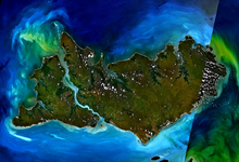
Landsat 7 imagery of the Tiwi Islands.
|
|
| Geography | |
| Location | Arafura Sea |
| Coordinates | 11°36′S 130°49′E / 11.600°S 130.817°ECoordinates: 11°36′S 130°49′E / 11.600°S 130.817°E |
| Total islands | 11 |
| Major islands |
Melville Island Bathurst Island |
| Area | 8,320 km2 (3,210 sq mi) |
| Coastline | 1,016 km (631.3 mi) |
| Administration | |
|
Australia
|
|
| State or territory | Northern Territory |
| LGA | Tiwi Islands Shire |
| Demographics | |
| Population | 2,579 (August 2011) |
| Pop. density | 0.31 /km2 (0.8 /sq mi) |
| Ethnic groups | Tiwi people |
| Additional information | |
| Official website | http://www.tiwiislands.nt.gov.au/ |
The Tiwi Islands are part of the Northern Territory, Australia, 80 km to the north of Darwin where the Arafura Sea joins the Timor Sea. They comprise Melville Island, Bathurst Island, and nine smaller uninhabited islands, with a combined area of 8,320 square kilometres (3,212 sq mi).
Inhabited before European settlement by the Tiwi indigenous Australians, there are approximately 3,000 people on the islands.
The Tiwi Land Council is one of four land councils in the Northern Territory. It is a representative body with statutory authority under the Aboriginal Land Rights (Northern Territory) Act 1976 and has responsibilities under the Native Title Act 1993 and the Pastoral Land Act 1992.
The Tiwi Islands lie 80 km to the north of the Australian mainland in the Arafura Sea, and are part of the Northern Territory. The island group consists of two large inhabited islands (Melville and Bathurst), and nine smaller uninhabited islands (Buchanan, Harris, Seagull, Karslake, Irritutu, Clift, Turiturina, Matingalia and Nodlaw). Bathurst Island is the fifth-largest island of Australia and accessible by sea or air. Melville Island is Australia's second largest island (after Tasmania).
The main islands are separated by Apsley Strait, which connects Saint Asaph Bay in the north and Shoal Bay in the south, and is between 550 metres and 5 km wide, 62 km long. At the mouth of Shoal Bay is Buchanan Island, with an area of about 3 km2. A car ferry at the narrowest point provides a quick connection between the two islands.
...
Wikipedia

