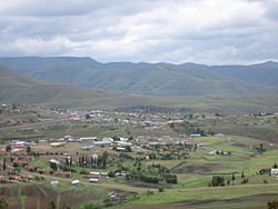
Thaba-Tseka District
| Thaba-Tseka | |
|---|---|
| District | |
 |
|
 Map of Lesotho with the district highlighted |
|
| Country |
|
| Area | |
| • Land | 1,650 sq mi (4,270 km2) |
| Population (2006) | |
| • Total | 129,137 |
| • Density | 80/sq mi (30/km2) |
| Time zone | CAT (UTC+2) |
Thaba-Tseka is a district of Lesotho. Thaba-Tseka is also the name of the district's capital or camptown, which is the only town in the district. In the east, Thaba-Tseka borders on the KwaZulu-Natal Province of South Africa. Domestically, it borders on Mokhotlong District in northeast, Leribe District in north, Berea District in northwest, Maseru District in west, Mohale's Hoek District in southwest and Qacha's Nek District in the southern direction.
As of 2006, the district had a population of 129,881 which was 6.92 per cent of the total population of the country. The total area of the district was 4,270 which was 14.07 per cent of the total area of the country. The density of population in the district was 30.00 per sq. km. As of 2008, there were 38 per cent economically active people in the district. There were totally 77,836 employed people out of a total of 156,640 people in the district above 15 years of age.
As of 2006, the district had a population of 129,881, 6.92 per cent of the population of the country. The total area of the district was 4,270, 14.07 per cent of the country. The population density in the district was 30.00 persons per square kilometre, compared to the 62 for the country. There were five constituencies and thirteen community councils in the district. As of 2006, 295 people tested HIV positive, 18.20 per cent of the HIV-positive persons in the country. 116 of these (14.50%) were men; 179 (20.50%) were women.
As of 2008, there were 38 per cent economically active people in the district. There were totally 77,836 employed people out of a total of 156,640 people in the district above 15 years of age. The employed population in the age group of 6-14 years was 2,578 out of a total of 51,962 people in the district in the age group. The labour force participation stood at 190.50. The number of people involved in subsistence agriculture is 1,828 and the number of people in other sectors was 750. The number of unemployed people in the district was 21,212 and the unemployment rate was 064. The total area planted in 2009 was 23,333 which formed 5.78 per cent of the total area planted in the country. The total production was 7,808 tonnes, which was 5.19 per cent of the totals in the country. The major crop was maize, while wheat, sorghum, beans and peas were the other crops planted. The total production of maize was 5,720 tonnes, beans was 318 tonnes, sorghum was 285 tonnes, peas was 775 tonnes and wheat was 710 tonnes as of 2008.
...
Wikipedia
