Mokhotlong District
| Mokhotlong | |
|---|---|
| District | |

Mokhotlong Airport
|
|
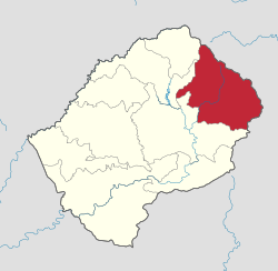
 Map of Lesotho with the district highlighted |
|
| Country |
|
| Government | |
| Area | |
| • Land | 1,573 sq mi (4,075 km2) |
| Population (2006) | |
| • Total | 96,340 |
| • Density | 60/sq mi (24/km2) |
| Time zone | CAT (UTC+2) |
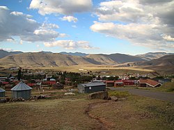
Mokhotlong district (in Sesotho language "the place of the bald ibis") is a district of Lesotho. It includes the highest terrain in the Maloti Range and the source of the Senqu River, Lesotho’s primary watershed. Mokhotlong is the capital or camptown, and only town in the district. Mokhotlong borders on the KwaZulu-Natal Province of South Africa, with its north point bordering the Free State Province. Domestically, it borders on Butha-Buthe District in northwest, Leribe District in west, and Thaba-Tseka District in the south.
As of 2006, the district had a population of 97,713 which was 5.21 per cent of the total population of the country. The total area of the district was 4,075 which was 13.42 per cent of the total area of the country. The density of population in the district was 24.00 per sq. km. As of 2008, there were 36 economically active people in the district. There were totally 66,290 employed people out of a total of 134,871people in the district above 15 years of age. The total are planted in 2009 was 16,420 which formed 4.07 per cent of the total area planted in the country. The total production was 8,757 tonnes, which was 5.82 per cent of the totals in the country.
As of 2006, the district had a population of 97,713 5.21 per cent of the population of the country. The area of the district was 4,075, 13.42 per cent of the country. The population density was 24.00 persons per square kilometre, compared to 62 for the country. There were four constituencies and fifteen community councils in the district. As of 2006, 250 people tested HIV positive, 17.70 of the HIV positive persons in the country. 97 of these (13.00%) were men; 153 (20.60%) were women.
As of 2008, there were 36 economically active people in the district. There were totally 66,290 employed people out of a total of 134,871people in the district above 15 years of age. The employed population in the age group of 6-14 years was 4,042 out of a total of 37,468 people in the district in the age group. The labour force participation stood at 181.10. The number of people involved in subsistence agriculture is 2,958 and the number of people in other sectors was 1,084. The number of unemployed people in the district was 14,382 and the unemployment rate was 054. The total are planted in 2009 was 16,420 which formed 4.07 per cent of the total area planted in the country. The total production was 8,757 tonnes, which was 5.82 per cent of the totals in the country. The major crop was maize, while wheat, sorghum, beans and peas were the other crops planted. The total production of maize was 6,508 tonnes, beans was 877 tonnes, sorghum was 355 tonnes, peas was 178 tonnes and wheat was 839 tonnes as of 2008.
...
Wikipedia
