Butha-Buthe District
| Butha-Bothe | |
|---|---|
| District | |

Image of Butha Buthe
|
|
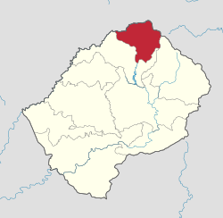
 Map of Lesotho with the district highlighted |
|
| Country |
|
| Area | |
| • Land | 682 sq mi (1,767 km2) |
| Population (2006) | |
| • Total | 109,529 |
| • Density | 160/sq mi (62/km2) |
| Time zone | CAT (UTC+2) |
Butha-Buthe is a district of Lesotho. Butha-Buthe is the capital or camptown, and only town in the district. In the north, Butha-Buthe borders on the Free State Province of South Africa. Domestically, it borders on Mokhotlong District in southeast and Leribe District on the south.
As of 2006, the district had a population of 110,320 which was 5.88 per cent of the total population of the country. The total area of the district was 1,767 which was 5.82 per cent of the total area of the country. As of 2008, there were 49 per cent economically active people in the district. There were totally 71,012 employed people out of a total of 154,384 people in the district above 15 years of age. The total are planted in 2009 was 7,164 which formed 1.77 per cent of the total area planted in the country.
As of 2006, the district had a population of 110,320, 5.88 per cent of the population of the country. The area of the district was 1,767, 5.82 per cent of the country. The population density was 62 persons per square kilometre, same as the country as a whole. There were five constituencies and ten community councils in the district. As of 2006, 323 persons tested HIV positive, 20.20 per cent of the country's HIV positive population. 128 of these were men (12.40 per cent); 195 were women (25.30 per cent).
In the north, Butha-Buthe borders on the Free State Province of South Africa. Domestically, it borders on Mokhotlong District in southeast and Leribe District on the south. It is traversed by the northwesterly line of equal latitude and longitude. The Western districts of Lesotho has predominantly low land zone with an elevation of 1,500 m (4,900 ft) 1,800 m (5,900 ft) above the sea level. These lands are the major agricultural zones in the country. The average annual rainfall in the country is 100 cm (39 in), most of which is received during the rainy season of October to April. Though it rains during all the months of the year, groundwater is limited on account of run-offs. The region has a temperate climate on account of the elevation and is humid during most parts of the year. The temperature in low lands vary from 32 °C (90 °F) to −7 °C (19 °F) in the winter.
...
Wikipedia
