Subi Reef
| Disputed island Other names: Zhubi Reef Chinese: 渚碧礁; pinyin: Zhǔbì Jiāo Tagalog: Zamora Vietnamese: đá Xu Bi |
|
|---|---|

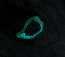
Landsat 7 Image (April 2000)
|
|
| Geography | |
| Location | South China Sea |
| Coordinates | 10°54′48″N 114°03′43″E / 10.9133°N 114.062°ECoordinates: 10°54′48″N 114°03′43″E / 10.9133°N 114.062°E |
| Archipelago | Spratly Islands |
| Administered by | |
| People's Republic of China | |
| Claimed by | |
| People's Republic of China | |
| Philippines | |
| Republic of China (Taiwan) | |
| Vietnam | |
Subi Reef, also known as Zhubi Reef (Chinese: 渚碧礁; pinyin: Zhǔbì Jiāo; Tagalog: Zamora; Vietnamese: đá Xu Bi) is a reef in the Spratly Islands of the South China Sea located 26 km (16 mi) southwest of Philippine-occupied Thitu Island. It is occupied by China, and claimed by Taiwan, Vietnam, and the Philippines. It currently falls under the jurisdiction of Nansha islands, Sansha city, Hainan province, China.
The atoll measures 5.7 km along its longer southwest-northeast axis, and is up to 3.5 km wide. Its total area including the lagoon and rim of the reef measures 16 km², and the lagoon is up to 22 meters deep.
Naturally above water only at low tide, the reef surrounds a lagoon. The People's Republic of China has constructed a 4-story building, a weather observation station with doppler weather radar, wharfs, and a helipad in the area. A buoyed channel guides ships to the inner lagoon which is 3.7 kilometers in diameter.
On 12 July 2016, the tribunal of the Permanent Court of Arbitration confirmed that Subi Reef is, or in their natural condition was, exposed at low tide and submerged at high tide and are, accordingly low-tide elevations that do not generate entitlement to a territorial sea, exclusive economic zone or continental shelf.
...
Wikipedia

