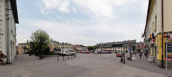
Strumień
| Strumień | ||
|---|---|---|

Town square
|
||
|
||
| Coordinates: 49°55′1.5″N 18°45′48.72″E / 49.917083°N 18.7635333°E | ||
| Country |
|
|
| Voivodeship | Silesian | |
| County | Cieszyn | |
| Gmina | Strumień | |
| Founded | 13th century | |
| First mentioned | 1407 | |
| Town rights | 1482 | |
| Government | ||
| • Mayor | Anna Agnieszka Grygierek | |
| Area | ||
| • Total | 6.45 km2 (2.49 sq mi) | |
| Population (June 2008) | ||
| • Total | 3,502 | |
| • Density | 540/km2 (1,400/sq mi) | |
| Time zone | CET (UTC+1) | |
| • Summer (DST) | CEST (UTC+2) | |
| Postal code | 43-246 | |
| Car plates | SCI | |
| Website | http://www.strumien.pl | |
Strumień [ˈstrumʲɛɲ] (German: Schwarzwasser, Czech: Strumeň) is a town and the seat of Gmina Strumień, in Cieszyn County, in the Silesian Voivodeship (province) of southern Poland, on the Vistula River.
It is located in the north-eastern part of the historical region of Cieszyn Silesia and is the smallest town in the region and one of the smallest in Poland.
The name is of topographic origin and is derived from a local stream (now non-existent) first mentioned in 1293, known as Czarny Strumień (lit. black stream, therefore Schwarzwasser in German). It is not certain if the settlement already existed then as the village was first mentioned later in 1407 as Swarczenwassir. Later the village was also mentioned as Swarczenwasser (1409), Strumienie (1450), na Strumyeny (1470), miesto Strumien (1491). Politically it belonged then to the Duchy of Racibórz a fee of the Kingdom of Bohemia. During the political upheaval beginning in the 1470s caused by Matthias Corvinus the land around Pszczyna with Strumień was overtaken by Casimir II, Duke of Cieszyn, who bestowed the village to his retainer, Mikołaj (Nicolaus) Brodecki, who quickly managed to procure town rights for it in 1482. Casimir II sold Pszczyna circle in 1517 but the town of Strumień stayed within the Duchy of Teschen. In 1526 the Kingdom of Bohemia became part of the Habsburg Monarchy.
...
Wikipedia


