State Highway 24 (Texas)
| State Highway 24 | ||||||||||||
|---|---|---|---|---|---|---|---|---|---|---|---|---|

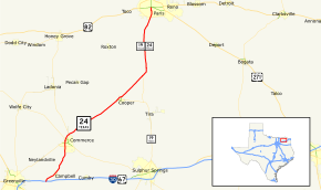
State Highway 24 highlighted in red
|
||||||||||||
| Route information | ||||||||||||
| Maintained by TxDOT | ||||||||||||
| Length: | 31.177 mi (50.175 km) | |||||||||||
| Existed: | c. July 6, 1917 – present | |||||||||||
| Major junctions | ||||||||||||
| South end: |
|
|||||||||||
| North end: |
|
|||||||||||
| Location | ||||||||||||
| Counties: | Hunt, Delta, Lamar | |||||||||||
| Highway system | ||||||||||||
|
||||||||||||
State Highway 24, or SH 24, runs from Campbell to Paris in north Texas. It is a portion of the main route, along with Interstate 30, from Paris to the Dallas/Fort Worth Metroplex.
When the Texas State Highway System was first laid out, SH 24 was defined as traveling along the Old Southern Trail, from Burkburnett through Wichita Falls, Archer City, Throckmorton, Albany, Baird, Mason, Fredericksburg, Boerne, San Antonio and Laredo. In 1917, SH 24 was designated from Denton to Whitesboro. The historic routing of SH 24 was one of the 26 original Texas state highways. By 1926, the routing had changed substantially. The original Denton to Whitesboro route was reassigned as SH 10. Portions of the former SH 22 (Graham to Olney) and SH 28 (Olney to Benjamin) were then reassigned as SH 24, which was now planned to reach from Jacksboro to Guthrie. By 1928, The highway extended south from Jacksboro to Mineral Wells, replacing a portion of the former SH 25. By 1931, the road from Jacksboro to Mineral Wells was transferred to SH 66. It was rerouted northeast to Paris, replacing SH 39, and west to New Mexico, replacing most of SH 53. But by 1939, this extended western plan had been dropped and the highway was rerouted west of Newcastle over SH 120 from Newcastle to Old Glory.
...
Wikipedia

