Staryi Krym
|
Staryi Krym Старий Крим Старый Крым Eski Qırım |
||
|---|---|---|
|
||
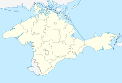
| Location of Staryi Krym within Crimea | ||
| Coordinates: 45°1′45″N 35°5′19″E / 45.02917°N 35.08861°ECoordinates: 45°1′45″N 35°5′19″E / 45.02917°N 35.08861°E | ||
| Country | Disputed: | |
| Republic | Crimea | |
| District | Kirovske Raion | |
| Area | ||
| • Total | 9.97 km2 (3.85 sq mi) | |
| Elevation | 300 m (1,000 ft) | |
| Population (2014) | ||
| • Total | 9,277 | |
| • Density | 1,000/km2 (3,000/sq mi) | |
| Time zone | MSK (UTC+3) | |
| Postal code | 97345 | |
| Area code(s) | +7-36555 | |
| Climate | Cfb | |
| Former name | Solkhat (until the 14th century) | |
| Website | solhat |
|
Staryi Krym (Ukrainian: Старий Крим, Russian: Старый Крым, Crimean Tatar: Eski Qırım) is a small historical town and former bishopric in Kirovske Raion of Crimea, an area currently disputed between Russia and Ukraine. It is located in the Eastern Crimean Peninsula, approximately 25 km (15 mi.) west of Theodosia. Population: 9,277 (2014 Census).
During the 13th century, the town was known as either Solkhat (Solkhad, Solghad, Ṣulġāt صلغات) or as Qrım (al-Qirim القرم). Both names are unattested prior to the 13th century, but on the authority of al-Qalqashandi, Solkhat is the older of the two, dating to the period prior to the Mongol conquest. The origin of either name is uncertain. Some consider it to be related to the Greek Colchis.
Both names coexisted during the 14th century, but the name Qırım came to displace Solkhat by the early 15th. Before the Mongol period, mention is made in Greek hagiography of the residence of the Khazar governor of the eastern part of the peninsula, as a fortress named Fulla or Fullai (Φούλλαι, although other sources identify this place with Chufut-Kale) along with Sugdaia (Sudak); it is likely that the site of this fortress corresponds to the site of Solghat.
The name Qirim may continue an old name Cimmerium (after the Cimmerians). The Strait of Kerch was known as Bosporus Cimmerius in the Roman era (as reported by Ptolemy and Strabo), after the city of Cimmerium which stood nearby. The promontory or peninsula on which it stood was known as Promontorium Cimmerium (Κιμμέριον ἄκρον). The 13th-century toponym Qrim is likely explained as a corruption of the name Cimmerium. There are however alternative suggestions, such as derivation from the Greek Cremnoi (Κρημνοί, in post-classical Koiné Greek pronunciation, Crimni, i.e., "the Cliffs", referenced by Herodotus 4.20.1 and 4.110.2), or from a Mongolian appellation.
...
Wikipedia


