St Kilda East
|
St Kilda East Melbourne, Victoria |
|||||||||||||
|---|---|---|---|---|---|---|---|---|---|---|---|---|---|

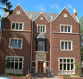
"770" Synagogue, Inkerman Street
|
|||||||||||||
| Coordinates | 37°51′43″S 144°59′49″E / 37.862°S 144.997°ECoordinates: 37°51′43″S 144°59′49″E / 37.862°S 144.997°E | ||||||||||||
| Population | 12,576 (2011 census) | ||||||||||||
| • Density | 5,470/km2 (14,160/sq mi) | ||||||||||||
| Established | 1850s | ||||||||||||
| Postcode(s) | 3183 | ||||||||||||
| Area | 2.3 km2 (0.9 sq mi) | ||||||||||||
| Location | 6 km (4 mi) from Melbourne | ||||||||||||
| LGA(s) | |||||||||||||
| State electorate(s) | |||||||||||||
| Federal Division(s) | Melbourne Ports | ||||||||||||
|
|||||||||||||
St Kilda East is a suburb of Melbourne, Victoria, Australia, 6 km south-east from Melbourne's Central Business District. It is located within the local government areas of the City of Glen Eira and the City of Port Phillip. At the 2011 Census, St Kilda East had a population of 12,576.
St Kilda East is one of the more diverse and densely populated suburbs of Melbourne. It has a prominent Hasidic Jewish community, descended from Polish and Russian immigrants. Quiet and residential, it is quite different from the adjacent suburb of St Kilda. However, the area around Carlisle Street is very diverse with a strong arts, alternative and indie community.
The St Kilda East area was first settled in the 1850s. Smaller timber shacks were common during the early 1860s to 1870s, with larger houses on the bigger subdivisions. During the late 1870s, terraced housing began around the railway line.
Alma Park was laid out and areas surrounding the park were set aside for religious purposes, resulting in a large number of convents and chapels along Chapel Street and either side of Dandenong Road. In the 1950s, speculative development resulted in the alteration of many of the suburb's streetscapes. Centred on Chapel Street and to the east of the railway line, flats became common in the area.
Recent development of the suburbs, rising land values and excellent access to public transport has seen recent gentrification in the area. Modern infill medium density apartments are being built on many blocks, with the Carlisle Street area designated an activity centre under the Melbourne 2030 planning scheme.
...
Wikipedia

