St. Marys River (Michigan–Ontario)
| St. Marys River | |
| Rivière Sainte-Marie | |
| River | |
|
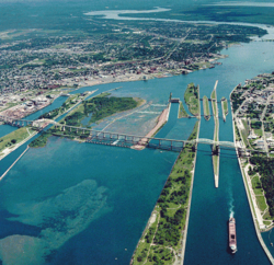
The Sault Ste. Marie International Bridge crossing the river at the Canada–United States border
|
|
| Countries | Canada, United States |
|---|---|
| Province/State | Ontario, Michigan |
| Cities | United States: Bay Mills, De Tour, Sault Ste. Marie, Soo, Sugar Island, Canada: Bruce Mines, Echo Bay, Hilton Beach, Jocelyn, MacLennan, St. Joseph, Sault Ste. Marie |
| Source | Whitefish Bay (Lake Superior) |
| - elevation | 600 ft (183 m) |
| - coordinates | 46°30′02″N 84°36′14″W / 46.50056°N 84.60389°W |
| Mouth | North Channel (Lake Huron) |
| - elevation | 577 ft (176 m) |
| - coordinates | 46°03′20″N 83°54′34″W / 46.05556°N 83.90944°WCoordinates: 46°03′20″N 83°54′34″W / 46.05556°N 83.90944°W |
| Length | 74.5 mi (120 km) |
| Discharge | |
| - average | 2,135 m3/s (75,397 cu ft/s) |
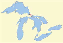
The St. Marys River (French: rivière Sainte-Marie), sometimes written as the St. Mary's River, drains Lake Superior, starting at the end of Whitefish Bay and flowing 74.5 miles (119.9 km) southeast into Lake Huron, with a fall of 23 feet (7.0 m). For its entire length it is an international border, separating Michigan in the United States from Ontario, Canada.
The twin cities of Sault Ste. Marie, Ontario, and Sault Ste. Marie, Michigan are connected across the St. Marys River by the Sault Ste. Marie International Bridge. The St. Marys Rapids are just below the river's exit from Lake Superior and can be bypassed by huge freight ships through the man-made Soo Locks and the Sault Ste. Marie Canal.
Two of the Ontario tributaries of this river are the Garden River and the Bar River. Other Canadian tributaries include Fort Creek, the Root River, the Little Carp River, the Big Carp River, the Lower Echo River, Desbarats River, and the Two Tree River. The American tributaries to the St. Mary River are the Gogomain River, the Munuscong River, the Little Munuscong River, the Charlotte River, and the Waiska River.
Before Europeans arrived, Native Americans fished, traded, and maintained a portage around the rapids. French explorer Étienne Brûlé was the first European to travel up the rapids in about 1621. In 1641 Jesuit priests Isaac Jogues and Charles Raymbault ventured the same route as Brûlé, finding many Ojibwe at the rapids, and named it . Sault (Middle and early Modern French spelling of saut) means "jump"; hence, the secondary meaning "rapids" because the water 'jumps.'
...
Wikipedia


