Sault Ste. Marie International Bridge
| Sault Ste. Marie International Bridge | |
|---|---|

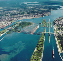
Aerial picture of the Sault Ste. Marie International Bridge and the Soo Locks
|
|
| Coordinates | 46°30′25″N 84°21′41″W / 46.50703°N 84.36132°WCoordinates: 46°30′25″N 84°21′41″W / 46.50703°N 84.36132°W |
| Carries | Two lanes of traffic ( |
| Crosses | St. Marys River |
| Locale | Sault Ste. Marie, Michigan-Sault Ste. Marie, Ontario |
| Characteristics | |
| Design | truss arch bridge |
| Total length | 2.8 miles (4.5 km) |
| Width | 28 feet (8.5 m) |
| Longest span | 132 m |
| Clearance below | 124 feet (38 m) |
| History | |
| Opened | 1962 |
| Statistics | |
| Daily traffic | 7,000 vehicles daily (average), 10,000 vehicles daily (peak) |
| Toll | US$3.50, CAD$3.70, |
The Sault Ste. Marie International Bridge spans the St. Marys River between the United States and Canada connecting the twin cities of Sault Ste. Marie, Michigan and Sault Ste. Marie, Ontario. It serves as the northern terminus of Interstate 75 (I-75). The International Bridge began construction in 1960 and officially opened to traffic on October 31, 1962. Daily operation is carried on by the International Bridge Administration (IBA) under the supervision of the Sault Ste. Marie Bridge Authority (SSMBA). The SSMBA replaced the previous Joint International Bridge Authority (JIBA) in 2009, which in turn had succeeded the International Bridge Authority (IBA, created in 1935) in 2000.
This is a steel truss arch bridge with suspended deck. There are two separate spans, a double arch span on the U.S. side and a single arch span on the Canadian side. The double arch spans cross the four U.S. Soo Locks. The single arch spans the single Canadian Lock. In Sault Ste. Marie, Ontario, the bridge ends at a city street, Huron Street, in the downtown core. The total length of the bridge approaches 2.8 miles (4.5 km). The Bridge allows bicycles to cross, but the lack of dedicated bike lanes requires cyclists to take proper precautions to ensure visibility.
The International Bridge Bus crosses the Bridge hourly from 7:00 am to 7:00 pm on weekdays and 9:00 am to 4:00 pm on Saturdays, serving both downtown areas and Lake Superior State University on the Michigan side and the Station Mall on the Ontario side.
A tourist information radio station, CIRS, broadcast at 530 AM from the Ontario side of the bridge until 2010.
In 1954 the state of Michigan created the International Bridge Authority. Canada followed in 1955, creating the St.Mary's River Co.
...
Wikipedia
