Southern Tier of New York State
| Southern Tier NY | |
| Region | |
|
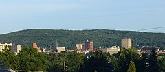
Skyline of Binghamton
|
|
| Country | United States |
|---|---|
| State | New York |
| Region | Upstate New York |
| Counties | Allegany, Broome, Cattaraugus, Tioga, Chautauqua, Chemung, Delaware, Steuben |
| Cities | Binghamton, Corning, Elmira, Hornell, Olean, Salamanca, Dunkirk, Jamestown, Vestal |
| Timezone | EST (UTC-5) |
| - summer (DST) | Eastern Daylight Time (UTC-4) |
| Area code | 607, 585 & 716 |
|
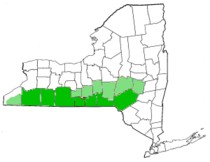
Core Southern Tier counties
Peripheral counties |
|
| Website: http://www.steg.com/ | |
The Southern Tier is the counties of New York west of the Catskill Mountains along the northern border of Pennsylvania. It generally includes the counties that border Pennsylvania west of Delaware County, but definitions of the region vary widely.
The region is bordered to the south by the Northern Tier of Pennsylvania, and together these regions are known as the Twin Tiers.
The eight counties almost always included in the Southern Tier are:
Often but less frequently included in the "Southern Tier" designation are Schuyler County, Yates County (the regional sentiment is stronger throughout the southern portions of Yates county, such as the village of Dundee), Cortland County, Tompkins County, and (far more rarely, except for Chenango) Schoharie County, Chenango County, and Otsego County (the last three of these, along with Broome County, are also commonly considered part of the tourist designation ""), however Schoharie County is also listed as part of the Capital District. At least one definition used by the state Department of Transportation includes Sullivan County, which usually isn't included in other definitions. The National Weather Service office in Buffalo occasionally includes Wyoming County and, more rarely, Southern Erie County in its definition.
...
Wikipedia


